
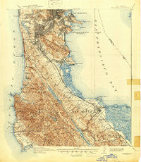
~ San Mateo CA topo map, 1:62500 scale, 15 X 15 Minute, Historical, 1915, updated 1947
San Mateo, California, USGS topographic map dated 1915.
Includes geographic coordinates (latitude and longitude). This topographic map is suitable for hiking, camping, and exploring, or framing it as a wall map.
Printed on-demand using high resolution imagery, on heavy weight and acid free paper, or alternatively on a variety of synthetic materials.
Topos available on paper, Waterproof, Poly, or Tyvek. Usually shipping rolled, unless combined with other folded maps in one order.
- Product Number: USGS-5683153
- Free digital map download (high-resolution, GeoPDF): San Mateo, California (file size: 11 MB)
- Map Size: please refer to the dimensions of the GeoPDF map above
- Weight (paper map): ca. 55 grams
- Map Type: POD USGS Topographic Map
- Map Series: HTMC
- Map Verison: Historical
- Cell ID: 62089
- Scan ID: 301599
- Imprint Year: 1947
- Survey Year: 1892
- Datum: Unstated
- Map Projection: Polyconic
- Map published by United States Geological Survey
- Keywords: Overedge with No Adjacent Map
- Map Language: English
- Scanner Resolution: 600 dpi
- Map Cell Name: San Mateo
- Grid size: 15 X 15 Minute
- Date on map: 1915
- Map Scale: 1:62500
- Geographical region: California, United States
Neighboring Maps:
All neighboring USGS topo maps are available for sale online at a variety of scales.
Spatial coverage:
Topo map San Mateo, California, covers the geographical area associated the following places:
- Fairway Park - Silver Penny Mobile Home Park - Franciscan Mobile Home Park - San Bruno - Treasure Island Mobile Home Park - San Mateo Park - Highlands - Hillsborough Park - Red Arrow Mobile Home Park - Ingleside - Ingleside Heights - Daly City - Pacific Skies Mobile Home Park - Pedro Valley - Diamond Heights Village - Broadmoor - Pacific Manor - Tanforan - Forest Hill - Sholun - Gold Mine Hill - South San Francisco - Rockaway Beach - Vallemar - Baywood Park - Broadmoor Village - Westborough - El Granada - Oceanview - Eldton - Silver Terrace - Lomita Park - Andry Mobile Home Park - Belle Monte - Saint Francis Wood - Bayshore - Laurel - Merced Manor - San Mateo - Stonestown - Foster City - Merced Heights - Baden - Glenridge - Meadowbrook Mobile Home Park - Millbrae - San Carlos - Linda Mar - Village Square - Devonshire - Hillsdale - Princeton - Park Merced - Burlingame - Bayview District - Sharp Park - West Portal - Millbrae Meadows - Sherwood Forest - El Granada Mobile Home Park - Westlake - Hillsborough - Belmont - Edgemar - Brisbane - Vista Del Monte - Ingleside Terrace - Hayward Park - Colma - Pacifica
- Map Area ID: AREA37.7537.5-122.5-122.25
- Northwest corner Lat/Long code: USGSNW37.75-122.5
- Northeast corner Lat/Long code: USGSNE37.75-122.25
- Southwest corner Lat/Long code: USGSSW37.5-122.5
- Southeast corner Lat/Long code: USGSSE37.5-122.25
- Northern map edge Latitude: 37.75
- Southern map edge Latitude: 37.5
- Western map edge Longitude: -122.5
- Eastern map edge Longitude: -122.25


