
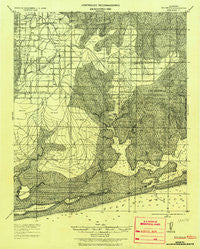
~ Bon Secour AL topo map, 1:62500 scale, 15 X 15 Minute, Historical, 1921, updated 1937
Bon Secour, Alabama, USGS topographic map dated 1921.
Includes geographic coordinates (latitude and longitude). This topographic map is suitable for hiking, camping, and exploring, or framing it as a wall map.
Printed on-demand using high resolution imagery, on heavy weight and acid free paper, or alternatively on a variety of synthetic materials.
Topos available on paper, Waterproof, Poly, or Tyvek. Usually shipping rolled, unless combined with other folded maps in one order.
- Product Number: USGS-5682645
- Free digital map download (high-resolution, GeoPDF): Bon Secour, Alabama (file size: 10 MB)
- Map Size: please refer to the dimensions of the GeoPDF map above
- Weight (paper map): ca. 55 grams
- Map Type: POD USGS Topographic Map
- Map Series: HTMC
- Map Verison: Historical
- Cell ID: 54217
- Scan ID: 305513
- Imprint Year: 1937
- Datum: Unstated
- Map Projection: Unstated
- Map published by United States Army Corps of Engineers
- Keywords: Nonstandard Press Run; Overedge with No Adjacent Map
- Map Language: English
- Scanner Resolution: 600 dpi
- Map Cell Name: Foley
- Grid size: 15 X 15 Minute
- Date on map: 1921
- Map Scale: 1:62500
- Geographical region: Alabama, United States
Neighboring Maps:
All neighboring USGS topo maps are available for sale online at a variety of scales.
Spatial coverage:
Topo map Bon Secour, Alabama, covers the geographical area associated the following places:
- Cedar Grove Mobile Home Park - C'est Lavie Mobile Home Park - Caswell - Summerdale - Pelican Mobile Home Park - Mallard Point Trailer Court - Whispering Winds Mobile Home Park - Romar Beach - Land Harbor Mobile Home Park - Country Crossroads Mobile Home Park - Swift - Foley Recreational Vehicle Park - Oyster Bay - Brewer Circle B Mobile Home Park - Bon Secour - Josephine - Foley - Thompson Mobile Home Park - Bay Village Mobile Home Park - Whispering Pines Mobile Home Park - Jacks Trailer Court - Douglas Mobile Home Park - Perdido Beach - Country Village Mobile Home Park - Helens Mobile Home Park and Recreational Vehicle Park - Oak - The Grove Mobile Home Park - Beech Camper and Mobile Home Park - Miflin - Dogwood Park Mobile Home Village and Recreational Vehicle Park - Cypress Acres Mobile Home Park - Moye Hill Park Mobile Home Park - Wolf Bay Park Mobile Home Park - Elijah Shoots Mobile Home Park - Orange Beach - Orchards Mobile Home Park - Oleander Court Mobile Home Park - Elberta - Blue Grass Recreational Vehicle Park
- Map Area ID: AREA30.530.25-87.75-87.5
- Northwest corner Lat/Long code: USGSNW30.5-87.75
- Northeast corner Lat/Long code: USGSNE30.5-87.5
- Southwest corner Lat/Long code: USGSSW30.25-87.75
- Southeast corner Lat/Long code: USGSSE30.25-87.5
- Northern map edge Latitude: 30.5
- Southern map edge Latitude: 30.25
- Western map edge Longitude: -87.75
- Eastern map edge Longitude: -87.5


