
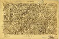
~ Birmingham AL topo map, 1:96000 scale, 30 X 30 Minute, Historical, 1904
Birmingham, Alabama, USGS topographic map dated 1904.
Includes geographic coordinates (latitude and longitude). This topographic map is suitable for hiking, camping, and exploring, or framing it as a wall map.
Printed on-demand using high resolution imagery, on heavy weight and acid free paper, or alternatively on a variety of synthetic materials.
Topos available on paper, Waterproof, Poly, or Tyvek. Usually shipping rolled, unless combined with other folded maps in one order.
- Product Number: USGS-5682643
- Free digital map download (high-resolution, GeoPDF): Birmingham, Alabama (file size: 10 MB)
- Map Size: please refer to the dimensions of the GeoPDF map above
- Weight (paper map): ca. 55 grams
- Map Type: POD USGS Topographic Map
- Map Series: HTMC
- Map Verison: Historical
- Cell ID: 65005
- Scan ID: 305744
- Survey Year: 1904
- Datum: Unstated
- Map Projection: Unstated
- Advance: Yes
- Map published by United States Geological Survey
- Keywords: Overedge; Nonstandard Press Run
- Map Language: English
- Scanner Resolution: 600 dpi
- Map Cell Name: Birmingham
- Grid size: 30 X 30 Minute
- Date on map: 1904
- Map Scale: 1:96000
- Geographical region: Alabama, United States
Neighboring Maps:
All neighboring USGS topo maps are available for sale online at a variety of scales.
Spatial coverage:
Topo map Birmingham, Alabama, covers the geographical area associated the following places:
- New Castle - Exum - Merrywood - Centerwood Estates - Cedar Grove (historical) - Eagle Ridge - Rose Hill - Woodland Village - Graystone - Damascus - Owenton - Bremen - Pratt City - North Birmingham - Brookmont - Meadowview Estates - East Thomas - Rock Ridge - Linton - Heatherwood - Thomas - Autumn Chase - Washington Heights - Spring Lake Estates - Oak Lawn - Forest Acres - Killough Springs - Breakstone Village - Brookside - Mount Olive - Markeeta - Thermal (historical) - Spring Garden - Red Hill - Compton - Black Bottom - Cahaba Landing - Parsons - Frenchtown - Avon Park - Hunters Hill - Cherokee Estates - Roebuck Springs - Overton - Majestic - Cane Creek - Lakewood - Marks Village - Minor - Sayre - Ingle Terrace - Ketona - Country Haven - Morningside - Chalkville - Irondale - Little Warrior - Trussville - Bagley Meadows - Cahaba Crest - Plain View - Cloverdale - Gurley - Danzler - Eastwood - West Ensley - Wahouma - Altamont Park - Balle Mobile Home Park - Sherwood Hills - Sunset Mountain - Whites Chapel - Biscayne Highlands - Danville - Fultondale - Oak Crossing - Valley Crest Estates - Blount Springs - Highland Residence Park - Oakhurst - McDonald Chapel - Jefferson Hills - Ridgewood - Mountain Park - Union Grove - North Lake Park - New Town - Oak Forest - Adville - Fitzgerald Estates - Inland Junction - Robbins Crossroads - Cahaba Village - Euclid Estates - Nyota - Village Springs - Daisey City Trailer Park - Plaza Mobile Home Park - Cotton Ridge - Brentwood
- Map Area ID: AREA3433.5-87-86.5
- Northwest corner Lat/Long code: USGSNW34-87
- Northeast corner Lat/Long code: USGSNE34-86.5
- Southwest corner Lat/Long code: USGSSW33.5-87
- Southeast corner Lat/Long code: USGSSE33.5-86.5
- Northern map edge Latitude: 34
- Southern map edge Latitude: 33.5
- Western map edge Longitude: -87
- Eastern map edge Longitude: -86.5


