
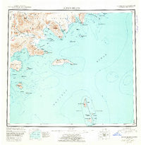
~ Sutwik Island AK topo map, 1:250000 scale, 1 X 2 Degree, Historical, 1951, updated 1962
Sutwik Island, Alaska, USGS topographic map dated 1951.
Includes geographic coordinates (latitude and longitude). This topographic map is suitable for hiking, camping, and exploring, or framing it as a wall map.
Printed on-demand using high resolution imagery, on heavy weight and acid free paper, or alternatively on a variety of synthetic materials.
Topos available on paper, Waterproof, Poly, or Tyvek. Usually shipping rolled, unless combined with other folded maps in one order.
- Product Number: USGS-5682509
- Free digital map download (high-resolution, GeoPDF): Sutwik Island, Alaska (file size: 11 MB)
- Map Size: please refer to the dimensions of the GeoPDF map above
- Weight (paper map): ca. 55 grams
- Map Type: POD USGS Topographic Map
- Map Series: HTMC
- Map Verison: Historical
- Cell ID: 75046
- Scan ID: 361478
- Imprint Year: 1962
- Datum: NAD27
- Map Projection: Universal Transverse Mercator
- Map published by United States Geological Survey
- Keywords: Overedge with No Adjacent Map
- Map Language: English
- Scanner Resolution: 600 dpi
- Map Cell Name: Sutwik Island
- Grid size: 1 X 2 Degree
- Date on map: 1951
- Map Scale: 1:250000
- Geographical region: Alaska, United States
Neighboring Maps:
All neighboring USGS topo maps are available for sale online at a variety of scales.
Spatial coverage:
Topo map Sutwik Island, Alaska, covers the geographical area associated the following places:
- Navy Island - Yantarni Bay - Cape Kumlik - Pinnacle Mountain - Jaw Mountain - Chiginagak Bay - Semidi National Wildlife Refuge - Hydra Island - Suklik Island - Misery Creek - Cape Kunmik - Cape Kunmik - Kumlik Island - Anowik Island - Kumliun Creek - Mountain Creek - Cupcake Island - West Creek - North Fork Yantarni Creek - Main Creek - Cape Horn - North Fork - Hidden Creek - Sutwik Island - Cape Kumliun - The Twins - Aiugnak Columns - Aniakchak River - Amber Bay - Black Creek - Semidi Islands - Cape Providence - Toee Reef - Radial Island - Yantarni Creek - Village Creek - Wolverine Creek - Flat Top Rock - Kujulik Bay - Nakchamik Island - Katmai Reef - Logan Reef - Northeast Creek - Semidi Wilderness - Cape Horn - North Fork Aniakchak River - Eagle Island - Derickson Island - Kateekuk Island - Albert Johnson Creek - Mystery Creek - Foggy Cape - Aghiyuk Island - Aniakchak National Preserve - Unavikshak Island - Aghik Island - Ugaiushak Island - Chowiet Island - Cape Kuyuyukak - Cape Ayutka - Atkulik Island - Meshik Lake - Home Creek - Garden Island - Cape Kumlik - Kiliktagik Island - Wiggly Creek - Central Island - Aniakchak Bay - Elephant Mountain - Devils Finger - Nakalilok Bay - Gull Island - Kak Island - Elephant Head Point
- Map Area ID: AREA5756-158-156
- Northwest corner Lat/Long code: USGSNW57-158
- Northeast corner Lat/Long code: USGSNE57-156
- Southwest corner Lat/Long code: USGSSW56-158
- Southeast corner Lat/Long code: USGSSE56-156
- Northern map edge Latitude: 57
- Southern map edge Latitude: 56
- Western map edge Longitude: -158
- Eastern map edge Longitude: -156


