
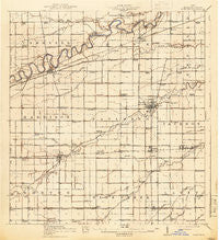
~ Paulding OH topo map, 1:62500 scale, 15 X 15 Minute, Historical, 1914, updated 1942
Paulding, Ohio, USGS topographic map dated 1914.
Includes geographic coordinates (latitude and longitude). This topographic map is suitable for hiking, camping, and exploring, or framing it as a wall map.
Printed on-demand using high resolution imagery, on heavy weight and acid free paper, or alternatively on a variety of synthetic materials.
Topos available on paper, Waterproof, Poly, or Tyvek. Usually shipping rolled, unless combined with other folded maps in one order.
- Product Number: USGS-5679885
- Free digital map download (high-resolution, GeoPDF): Paulding, Ohio (file size: 7 MB)
- Map Size: please refer to the dimensions of the GeoPDF map above
- Weight (paper map): ca. 55 grams
- Map Type: POD USGS Topographic Map
- Map Series: HTMC
- Map Verison: Historical
- Cell ID: 60814
- Scan ID: 227460
- Imprint Year: 1942
- Survey Year: 1911
- Datum: Unstated
- Map Projection: Polyconic
- Map published by United States Geological Survey
- Keywords: Overedge
- Map Language: English
- Scanner Resolution: 600 dpi
- Map Cell Name: Paulding
- Grid size: 15 X 15 Minute
- Date on map: 1914
- Map Scale: 1:62500
- Geographical region: Ohio, United States
Neighboring Maps:
All neighboring USGS topo maps are available for sale online at a variety of scales.
Spatial coverage:
Topo map Paulding, Ohio, covers the geographical area associated the following places:
- Latty - Briceton - Broughton - Follmer (historical) - Paulding - Mooney Meadows Subdivision - Antwerp - Reids (historical) - Worstville - Payne - Horneys Mobile Home Park - Haviland - Sophia (historical) - Arena (historical) - Cecil - Logtown - Colters Mobile Home Park - Tipton - Emmett - Riverbend Mobile Home Park - Knoxdale - Batson - New Rochester - Dague - Hedges - Riverview Park Subdivision
- Map Area ID: AREA41.2541-84.75-84.5
- Northwest corner Lat/Long code: USGSNW41.25-84.75
- Northeast corner Lat/Long code: USGSNE41.25-84.5
- Southwest corner Lat/Long code: USGSSW41-84.75
- Southeast corner Lat/Long code: USGSSE41-84.5
- Northern map edge Latitude: 41.25
- Southern map edge Latitude: 41
- Western map edge Longitude: -84.75
- Eastern map edge Longitude: -84.5


