
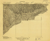
~ Pounding Mill VA topo map, 1:48000 scale, 15 X 15 Minute, Historical, 1915
Pounding Mill, Virginia, USGS topographic map dated 1915.
Includes geographic coordinates (latitude and longitude). This topographic map is suitable for hiking, camping, and exploring, or framing it as a wall map.
Printed on-demand using high resolution imagery, on heavy weight and acid free paper, or alternatively on a variety of synthetic materials.
Topos available on paper, Waterproof, Poly, or Tyvek. Usually shipping rolled, unless combined with other folded maps in one order.
- Product Number: USGS-5678976
- Free digital map download (high-resolution, GeoPDF): Pounding Mill, Virginia (file size: 13 MB)
- Map Size: please refer to the dimensions of the GeoPDF map above
- Weight (paper map): ca. 55 grams
- Map Type: POD USGS Topographic Map
- Map Series: HTMC
- Map Verison: Historical
- Cell ID: 61252
- Scan ID: 187730
- Survey Year: 1915
- Datum: Unstated
- Map Projection: Unstated
- Advance: Yes
- Map published by United States Geological Survey
- Keywords: Nonstandard Press Run; Overedge
- Map Language: English
- Scanner Resolution: 600 dpi
- Map Cell Name: Pounding Mill
- Grid size: 15 X 15 Minute
- Date on map: 1915
- Map Scale: 1:48000
- Geographical region: Virginia, United States
Neighboring Maps:
All neighboring USGS topo maps are available for sale online at a variety of scales.
Spatial coverage:
Topo map Pounding Mill, Virginia, covers the geographical area associated the following places:
- Adria - Maxwell - Canebrake - Bearwallow - Youngs (historical) - Squire - Pleasant Hill - Shraders - Gap Store - Faraday - Rourkes Gap - Pounding Mill - Stony Ridge - Pisgah - Bandy - Benbow - River Jack - Jacobs Fork - Tazewell - Pucketts Store - Wittens Fort - North Tazewell - Asberrys - Rockhouse - Lamberts Store - Bishop - Green Place - Horsepen Cove - Dunford Village - Harman - Van Dyke - Mount Gate - Mouth of Laurel - Gillespie - Camp Tazewell - Whites Store - Cliffield - McCall Place - Vallscreek - Joe Whites - Amonate - Maiden Spring - Liberty - Bevers Store (historical) - Criggers - Horsepen - Brewsterdale - Frog Level - Thompson Valley - Johnstown - Hix (historical) - Busthead - Sayersville
- Map Area ID: AREA37.2537-81.75-81.5
- Northwest corner Lat/Long code: USGSNW37.25-81.75
- Northeast corner Lat/Long code: USGSNE37.25-81.5
- Southwest corner Lat/Long code: USGSSW37-81.75
- Southeast corner Lat/Long code: USGSSE37-81.5
- Northern map edge Latitude: 37.25
- Southern map edge Latitude: 37
- Western map edge Longitude: -81.75
- Eastern map edge Longitude: -81.5


