
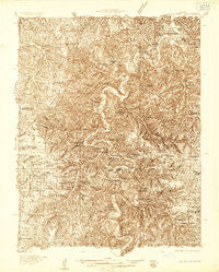
~ Macks Creek MO topo map, 1:48000 scale, 15 X 15 Minute, Historical, 1934
Macks Creek, Missouri, USGS topographic map dated 1934.
Includes geographic coordinates (latitude and longitude). This topographic map is suitable for hiking, camping, and exploring, or framing it as a wall map.
Printed on-demand using high resolution imagery, on heavy weight and acid free paper, or alternatively on a variety of synthetic materials.
Topos available on paper, Waterproof, Poly, or Tyvek. Usually shipping rolled, unless combined with other folded maps in one order.
- Product Number: USGS-5678648
- Free digital map download (high-resolution, GeoPDF): Macks Creek, Missouri (file size: 20 MB)
- Map Size: please refer to the dimensions of the GeoPDF map above
- Weight (paper map): ca. 55 grams
- Map Type: POD USGS Topographic Map
- Map Series: HTMC
- Map Verison: Historical
- Cell ID: 57018
- Scan ID: 324649
- Survey Year: 1934
- Datum: NAD27
- Map Projection: Polyconic
- Advance: Yes
- Map published by United States Geological Survey
- Keywords: Nonstandard Press Run; Overedge
- Map Language: English
- Scanner Resolution: 600 dpi
- Map Cell Name: Macks Creek
- Grid size: 15 X 15 Minute
- Date on map: 1934
- Map Scale: 1:48000
- Geographical region: Missouri, United States
Neighboring Maps:
All neighboring USGS topo maps are available for sale online at a variety of scales.
Spatial coverage:
Topo map Macks Creek, Missouri, covers the geographical area associated the following places:
- Tom Hollow Ford (historical) - Smith Ford (historical) - Prosperine - White City - Pleasant Grove - Ralphwhite Ford (historical) - Gilbertson Ford (historical) - Ira - Turner Ford (historical) - Case - Only - McPheters Ford (historical) - Hahatonka - Miller Ford (historical) - Roach - Leadmine - Rodger Ford (historical) - Herrick Ford - Sweet Hollow Ford (historical) - Corkery - Celt - Macks Creek - Berry Ford (historical) - Westfield - Green Gables (historical)
- Map Area ID: AREA3837.75-93-92.75
- Northwest corner Lat/Long code: USGSNW38-93
- Northeast corner Lat/Long code: USGSNE38-92.75
- Southwest corner Lat/Long code: USGSSW37.75-93
- Southeast corner Lat/Long code: USGSSE37.75-92.75
- Northern map edge Latitude: 38
- Southern map edge Latitude: 37.75
- Western map edge Longitude: -93
- Eastern map edge Longitude: -92.75


