
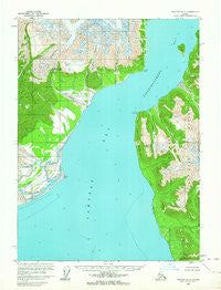
~ Yakutat D 5 AK topo map, 1:63360 scale, 15 X 15 Minute, Historical, 1959, updated 1964
Yakutat D 5, Alaska, USGS topographic map dated 1959.
Includes geographic coordinates (latitude and longitude). This topographic map is suitable for hiking, camping, and exploring, or framing it as a wall map.
Printed on-demand using high resolution imagery, on heavy weight and acid free paper, or alternatively on a variety of synthetic materials.
Topos available on paper, Waterproof, Poly, or Tyvek. Usually shipping rolled, unless combined with other folded maps in one order.
- Product Number: USGS-5675528
- Free digital map download (high-resolution, GeoPDF): Yakutat D 5, Alaska (file size: 10 MB)
- Map Size: please refer to the dimensions of the GeoPDF map above
- Weight (paper map): ca. 55 grams
- Map Type: POD USGS Topographic Map
- Map Series: HTMC
- Map Verison: Historical
- Cell ID: 64768
- Scan ID: 353879
- Imprint Year: 1964
- Woodland Tint: Yes
- Aerial Photo Year: 1954
- Datum: NAD27
- Map Projection: Universal Transverse Mercator
- Map published by United States Geological Survey
- Map Language: English
- Scanner Resolution: 600 dpi
- Map Cell Name: Yakutat D-5
- Grid size: 15 X 15 Minute
- Date on map: 1959
- Map Scale: 1:63360
- Geographical region: Alaska, United States
Neighboring Maps:
All neighboring USGS topo maps are available for sale online at a variety of scales.
Spatial coverage:
Topo map Yakutat D 5, Alaska, covers the geographical area associated the following places:
- Atrevida Glacier - Black Glacier - Aquadulce Creek - Disenchantment Bay - Logan Bluffs - Esker Stream - Strawberry Island - Latouche Glacier - Amphitheater Knob - Kwik Delta - Bancas Point - Aka Lake - Haenke Island - Grand Wash River - Calahonda Creek - Point Latouche - Blizhni Point - Galiano Glacier - Hubbard Glacier Geological Area - New Reef - Terrace Point - Logan Beach - Mount Hoorts - Indian Camp Creek
- Map Area ID: AREA6059.75-139.875-139.5
- Northwest corner Lat/Long code: USGSNW60-139.875
- Northeast corner Lat/Long code: USGSNE60-139.5
- Southwest corner Lat/Long code: USGSSW59.75-139.875
- Southeast corner Lat/Long code: USGSSE59.75-139.5
- Northern map edge Latitude: 60
- Southern map edge Latitude: 59.75
- Western map edge Longitude: -139.875
- Eastern map edge Longitude: -139.5


