
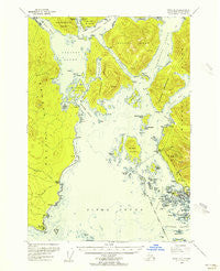
~ Sitka A 5 AK topo map, 1:63360 scale, 15 X 15 Minute, Historical, 1948, updated 1956
Sitka A 5, Alaska, USGS topographic map dated 1948.
Includes geographic coordinates (latitude and longitude). This topographic map is suitable for hiking, camping, and exploring, or framing it as a wall map.
Printed on-demand using high resolution imagery, on heavy weight and acid free paper, or alternatively on a variety of synthetic materials.
Topos available on paper, Waterproof, Poly, or Tyvek. Usually shipping rolled, unless combined with other folded maps in one order.
- Product Number: USGS-5672868
- Free digital map download (high-resolution, GeoPDF): Sitka A 5, Alaska (file size: 9 MB)
- Map Size: please refer to the dimensions of the GeoPDF map above
- Weight (paper map): ca. 55 grams
- Map Type: POD USGS Topographic Map
- Map Series: HTMC
- Map Verison: Historical
- Cell ID: 62603
- Scan ID: 359091
- Imprint Year: 1956
- Woodland Tint: Yes
- Aerial Photo Year: 1948
- Datum: NAD27
- Map Projection: Universal Transverse Mercator
- Map published by United States Geological Survey
- Map Language: English
- Scanner Resolution: 600 dpi
- Map Cell Name: Sitka A-5
- Grid size: 15 X 15 Minute
- Date on map: 1948
- Map Scale: 1:63360
- Geographical region: Alaska, United States
Neighboring Maps:
All neighboring USGS topo maps are available for sale online at a variety of scales.
Spatial coverage:
Topo map Sitka A 5, Alaska, covers the geographical area associated the following places:
- Beehive Island - The Eckholms - East Channel Hayward Strait - Neva Point - KIFW-AM (Sitka) - Sentinel Rock - West Channel Hayward Strait - Mitchell Rock - Crow Island - Old Sitka - United States Coast Guard Air Station EMS - Sitka - Harbor Point - Apple Islands - Whitestone Point - Lisianski Point - Guardian Flight Sitka - Rashimosti Island - Smith Island - Bart Island - Castle Hill - American Flag-Raising Site - Fort Rousseau (historical) - Vitskari Rocks - Volga Island - Southeast Alaska Regional Health Consortium Mount Edgecumbe Hospital - Old Sitka Rocks - Usher Rock - Sitka Naval Operating Base (historical) - Middle Island - Gagarin Island - Freds Creek - Creek Point - Sukoi Inlet - United States Customs and Border Protection Port of Entry Sitka - Pritchard Rock - Hayward Strait - Eastern Bay - Port Krestof - Sitka Seaplane Base - Olga Strait - Rockwell Island - Mertz Island - Channel Rock - Granite Creek - Promisla Bay - Kresta Point - Siginaka Islands - Starrigavan Campground - Watson Point - Chaichei Islands - Krestof Mountain - Charcoal Island - Rose Rock - Halleck Island - Bare Rock - Japonski Island - Sitka Public Health Center - Southeast Region - Whitestone Narrows - Kamenoi Point - Sitka Post Office Pioneer Station - Magoun Islands - Simpson Rock - Stewart Island - KTNL-TV (Sitka) - Sealing Cove - Whitestone Cove - Krugloi Point - Magoun Islands State Marine Park - Bieli Rocks - Western Anchorage - Shoals Point - Sitka Fire Department - Saint Michael's Cathedral - Halleck Point - Harbor Island - Halibut Point Recreation Center - Western Channel - Cedar Cove - Nicholson Rocks - Turning Island - South East Alaska Regional Health Consortium - Air Medical Service - Whiting Harbor - Escape Cape - Keene Rock - Sitka Police Department - Double Island - Line Island - Black Rock - Sitka Women Infant and Children Clinic - Nepovorotni Rocks - Mogilnoi Island - Parker Group - Aleutski Island - Gold Island - Mills Island - Coast Guard Air Station Sitka - Cascade Creek Dam - Vitskari Island - Swan Lake - Bare Island
- Map Area ID: AREA57.2557-135.6666667-135.3333333
- Northwest corner Lat/Long code: USGSNW57.25-135.6666667
- Northeast corner Lat/Long code: USGSNE57.25-135.3333333
- Southwest corner Lat/Long code: USGSSW57-135.6666667
- Southeast corner Lat/Long code: USGSSE57-135.3333333
- Northern map edge Latitude: 57.25
- Southern map edge Latitude: 57
- Western map edge Longitude: -135.6666667
- Eastern map edge Longitude: -135.3333333


