
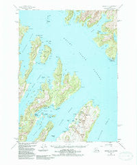
~ Seward A 3 AK topo map, 1:63360 scale, 15 X 15 Minute, Historical, 1951, updated 1988
Seward A 3, Alaska, USGS topographic map dated 1951.
Includes geographic coordinates (latitude and longitude). This topographic map is suitable for hiking, camping, and exploring, or framing it as a wall map.
Printed on-demand using high resolution imagery, on heavy weight and acid free paper, or alternatively on a variety of synthetic materials.
Topos available on paper, Waterproof, Poly, or Tyvek. Usually shipping rolled, unless combined with other folded maps in one order.
- Product Number: USGS-5672422
- Free digital map download (high-resolution, GeoPDF): Seward A 3, Alaska (file size: 14 MB)
- Map Size: please refer to the dimensions of the GeoPDF map above
- Weight (paper map): ca. 55 grams
- Map Type: POD USGS Topographic Map
- Map Series: HTMC
- Map Verison: Historical
- Cell ID: 62362
- Scan ID: 358869
- Imprint Year: 1988
- Woodland Tint: Yes
- Aerial Photo Year: 1982
- Edit Year: 1988
- Datum: NAD27
- Map Projection: Universal Transverse Mercator
- Map published by United States Geological Survey
- Map Language: English
- Scanner Resolution: 600 dpi
- Map Cell Name: Seward A-3
- Grid size: 15 X 15 Minute
- Date on map: 1951
- Map Scale: 1:63360
- Geographical region: Alaska, United States
Neighboring Maps:
All neighboring USGS topo maps are available for sale online at a variety of scales.
Spatial coverage:
Topo map Seward A 3, Alaska, covers the geographical area associated the following places:
- Horseshoe Bay (historical) - Port San Juan - Port Crawford (historical) - Latouche - Port Benney (historical) - Girwood (historical) - Phoenix (historical) - Chenega Bay - Chenega - Port Ashton - Oceanic
- Map Area ID: AREA60.2560-148.125-147.75
- Northwest corner Lat/Long code: USGSNW60.25-148.125
- Northeast corner Lat/Long code: USGSNE60.25-147.75
- Southwest corner Lat/Long code: USGSSW60-148.125
- Southeast corner Lat/Long code: USGSSE60-147.75
- Northern map edge Latitude: 60.25
- Southern map edge Latitude: 60
- Western map edge Longitude: -148.125
- Eastern map edge Longitude: -147.75


