
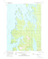
~ Port Alexander B 1 AK topo map, 1:63360 scale, 15 X 15 Minute, Historical, 1953, updated 1983
Port Alexander B 1, Alaska, USGS topographic map dated 1953.
Includes geographic coordinates (latitude and longitude). This topographic map is suitable for hiking, camping, and exploring, or framing it as a wall map.
Printed on-demand using high resolution imagery, on heavy weight and acid free paper, or alternatively on a variety of synthetic materials.
Topos available on paper, Waterproof, Poly, or Tyvek. Usually shipping rolled, unless combined with other folded maps in one order.
- Product Number: USGS-5671628
- Free digital map download (high-resolution, GeoPDF): Port Alexander B 1, Alaska (file size: 11 MB)
- Map Size: please refer to the dimensions of the GeoPDF map above
- Weight (paper map): ca. 55 grams
- Map Type: POD USGS Topographic Map
- Map Series: HTMC
- Map Verison: Historical
- Cell ID: 73118
- Scan ID: 358465
- Imprint Year: 1983
- Woodland Tint: Yes
- Aerial Photo Year: 1948
- Edit Year: 1966
- Datum: NAD27
- Map Projection: Universal Transverse Mercator
- Map published by United States Geological Survey
- Map Language: English
- Scanner Resolution: 600 dpi
- Map Cell Name: Port Alexander B-1
- Grid size: 15 X 15 Minute
- Date on map: 1953
- Map Scale: 1:63360
- Geographical region: Alaska, United States
Neighboring Maps:
All neighboring USGS topo maps are available for sale online at a variety of scales.
Spatial coverage:
Topo map Port Alexander B 1, Alaska, covers the geographical area associated the following places:
- Petrof Bay - Troller Islands - Explorer Basin - Step Island - Swaine Point - Thetis Bay - Point Cosmos - Port Malmesbury - Windfall Islands - Happy Cove - Point Harris - Lisa Point - Oyster Rock - Kuiu Wilderness - Troller Point - Gedney Harbor - North Mountain - Harris Cove - East Island - White Mountain - Elena Point - Shelter Cove - Green Mountain - Helianthus Passage - Davis Rock - Orel Anchorage - Tebenkof Bay Wilderness - Gap Point
- Map Area ID: AREA56.556.25-134.3333333-134
- Northwest corner Lat/Long code: USGSNW56.5-134.3333333
- Northeast corner Lat/Long code: USGSNE56.5-134
- Southwest corner Lat/Long code: USGSSW56.25-134.3333333
- Southeast corner Lat/Long code: USGSSE56.25-134
- Northern map edge Latitude: 56.5
- Southern map edge Latitude: 56.25
- Western map edge Longitude: -134.3333333
- Eastern map edge Longitude: -134


