
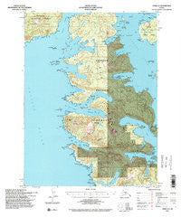
~ Craig A 4 AK topo map, 1:63360 scale, 15 X 15 Minute, Historical, 1994, updated 1998
Craig A 4, Alaska, USGS topographic map dated 1994.
Includes geographic coordinates (latitude and longitude). This topographic map is suitable for hiking, camping, and exploring, or framing it as a wall map.
Printed on-demand using high resolution imagery, on heavy weight and acid free paper, or alternatively on a variety of synthetic materials.
Topos available on paper, Waterproof, Poly, or Tyvek. Usually shipping rolled, unless combined with other folded maps in one order.
- Product Number: USGS-5665306
- Free digital map download (high-resolution, GeoPDF): Craig A 4, Alaska (file size: 18 MB)
- Map Size: please refer to the dimensions of the GeoPDF map above
- Weight (paper map): ca. 55 grams
- Map Type: POD USGS Topographic Map
- Map Series: HTMC
- Map Verison: Historical
- Cell ID: 53033
- Scan ID: 355252
- Imprint Year: 1998
- Woodland Tint: Yes
- Visual Version Number: 1
- Aerial Photo Year: 1992
- Datum: NAD27
- Map Projection: Transverse Mercator
- Map published by United States Geological Survey
- Map published by United States Forest Service
- Map Language: English
- Scanner Resolution: 600 dpi
- Map Cell Name: Craig A-4
- Grid size: 15 X 15 Minute
- Date on map: 1994
- Map Scale: 1:63360
- Geographical region: Alaska, United States
Neighboring Maps:
All neighboring USGS topo maps are available for sale online at a variety of scales.
Spatial coverage:
Topo map Craig A 4, Alaska, covers the geographical area associated the following places:
- Cone Mountain - Sea Otter Harbor - Bobs Bay - Millar Rocks - Manhattan Arm Sea Otter Harbor - Sakie Point - The Sentinels - Coco Harbor - View Cove - Eagle Point - Manhattan Lake - Breezy Bay - Meares Passage - Sakie Bay - Way Point - The Sentinels - Natalia Point - Diver Point - Halibut Nose - Green Inlet - Farallon Bay - Bruin Point - Lively Islands - Hole-in-the-Wall - Entrance Island - Round Island - Thunder Mountain - Devil Island - Middle Island - Hook Arm - Solyanka Point - Manhattan Arm - Low Rock - Windy Cove - Black Rock - Entrance Island - Clear Point - Juel Point - Diver Islands - North Bay - Camp Island - Devil Lake - Guide Island - Channel Island - Table Rock - Bear Mountain - Eolus Point - Gate Island - Fisherman Cove - Boreas Point - Sangao Island - Foul Bay - White Mountain - Francis Point - Squaw Mountain - Natalia Island - Cayman Point - Nellag Island - Hassler Point - Diver Bay - Diver Rocks - Clam Island - Cape Lookout
- Map Area ID: AREA55.2555-133.3333333-133
- Northwest corner Lat/Long code: USGSNW55.25-133.3333333
- Northeast corner Lat/Long code: USGSNE55.25-133
- Southwest corner Lat/Long code: USGSSW55-133.3333333
- Southeast corner Lat/Long code: USGSSE55-133
- Northern map edge Latitude: 55.25
- Southern map edge Latitude: 55
- Western map edge Longitude: -133.3333333
- Eastern map edge Longitude: -133


