
~ Cold Bay A 2 AK topo map, 1:63360 scale, 15 X 15 Minute, Historical, 1995, updated 1995
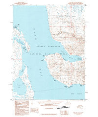
Cold Bay A 2, Alaska, USGS topographic map dated 1995.
Includes geographic coordinates (latitude and longitude). This topographic map is suitable for hiking, camping, and exploring, or framing it as a wall map.
Printed on-demand using high resolution imagery, on heavy weight and acid free paper, or alternatively on a variety of synthetic materials.
Topos available on paper, Waterproof, Poly, or Tyvek. Usually shipping rolled, unless combined with other folded maps in one order.
- Product Number: USGS-5664942
- Free digital map download (high-resolution, GeoPDF): Cold Bay A 2, Alaska (file size: 14 MB)
- Map Size: please refer to the dimensions of the GeoPDF map above
- Weight (paper map): ca. 55 grams
- Map Type: POD USGS Topographic Map
- Map Series: HTMC
- Map Verison: Historical
- Cell ID: 77081
- Scan ID: 355064
- Imprint Year: 1995
- Aerial Photo Year: 1991
- Edit Year: 1995
- Datum: NAD27
- Map Projection: Universal Transverse Mercator
- Provisional map: Yes
- Map published by United States Geological Survey
- Map Language: English
- Scanner Resolution: 600 dpi
- Map Cell Name: Cold Bay A-2
- Grid size: 15 X 15 Minute
- Date on map: 1995
- Map Scale: 1:63360
- Geographical region: Alaska, United States
Neighboring Maps:
All neighboring USGS topo maps are available for sale online at a variety of scales.
Spatial coverage:
Topo map Cold Bay A 2, Alaska, covers the geographical area associated the following places:
- Thinpoint Lake - Kaslokan Point - Cold Bay - Mortensens Lagoon - Old Mans Lagoon - Morgan Point - Delta Creek - Lenard Harbor - Bear Rock - Vodapoini Point - Nurse Lagoon - Delta Point - Kelp Point
- Map Area ID: AREA55.2555-162.6666667-162.3333333
- Northwest corner Lat/Long code: USGSNW55.25-162.6666667
- Northeast corner Lat/Long code: USGSNE55.25-162.3333333
- Southwest corner Lat/Long code: USGSSW55-162.6666667
- Southeast corner Lat/Long code: USGSSE55-162.3333333
- Northern map edge Latitude: 55.25
- Southern map edge Latitude: 55
- Western map edge Longitude: -162.6666667
- Eastern map edge Longitude: -162.3333333


