
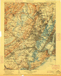
~ Passaic NJ topo map, 1:125000 scale, 30 X 30 Minute, Historical, 1905, updated 1909
Passaic, New Jersey, USGS topographic map dated 1905.
Includes geographic coordinates (latitude and longitude). This topographic map is suitable for hiking, camping, and exploring, or framing it as a wall map.
Printed on-demand using high resolution imagery, on heavy weight and acid free paper, or alternatively on a variety of synthetic materials.
Topos available on paper, Waterproof, Poly, or Tyvek. Usually shipping rolled, unless combined with other folded maps in one order.
- Product Number: USGS-5658976
- Free digital map download (high-resolution, GeoPDF): Passaic, New Jersey (file size: 12 MB)
- Map Size: please refer to the dimensions of the GeoPDF map above
- Weight (paper map): ca. 55 grams
- Map Type: POD USGS Topographic Map
- Map Series: HTMC
- Map Verison: Historical
- Cell ID: 66431
- Scan ID: 255443
- Imprint Year: 1909
- Survey Year: 1903
- Datum: Unstated
- Map Projection: Unstated
- Map published by United States Geological Survey
- Keywords: Overedge
- Map Language: English
- Scanner Resolution: 600 dpi
- Map Cell Name: Passaic
- Grid size: 30 X 30 Minute
- Date on map: 1905
- Map Scale: 1:125000
- Geographical region: New Jersey, United States
Neighboring Maps:
All neighboring USGS topo maps are available for sale online at a variety of scales.
Spatial coverage:
Topo map Passaic, New Jersey, covers the geographical area associated the following places:
- Kearny - Clifton - Dyker Heights - Orange - Haledon - Pines Lake - Graniteville - Travis - New Dover - Bayonne - Rochelle Park - Richfield - Morehousetown - Saint Cloud - Arrochar - Woodbridge - Ho-Ho-Kus - Parsippany - Bloomfield - Fairwoods - Clifton - The Village at Little Falls - Netherwood - Linden - Lincoln Park - Metuchen - Tremley - Mravlag Manor - Riverdale - Franklin - Newark - Jefferson Park - Cherry Hill - Fort Wadsworth - Possumtown - South Hackensack - West New Brighton - Newstead North - Glen Rock - Elmwood Park - New Market - Paterson - Livingston - Verona - Roselle Park - Westerleigh - Wallington - Meadow Village - Lahiere - Cranford Junction - Overlook - Fanwood - Seagate - Jersey City - Ampere - Packanack Lake - Pleasant Plains - Old Town Station - Pioneer Homes - Richmond Terrace Houses - Charleston - Vanguard Mobile Home Park - Homestead Park - Lake View - Hamilton Park - Red Hook Houses - Brookdale - Teaneck - Two Bridges - Athenia - Lyonsville - Morris Plains - Tribeca - Raritan Manor - Oakwood Park - Kenilworth - Hickory Tree - Lake Arrowhead - Cobbs Corner - Oakwood Heights Station - Allwood - Stony Hill - West View - Free Acres - North Arlington - Great Notch - Pleasantville - Madison Heights - Edgar - Arlington - North Bergen - Edwin Markham Gardens - North Haledon - Sand Hills - Northfield - Union Village - Tremont Park - Warren Point - Riverside - Mariners Harbor
- Map Area ID: AREA4140.5-74.5-74
- Northwest corner Lat/Long code: USGSNW41-74.5
- Northeast corner Lat/Long code: USGSNE41-74
- Southwest corner Lat/Long code: USGSSW40.5-74.5
- Southeast corner Lat/Long code: USGSSE40.5-74
- Northern map edge Latitude: 41
- Southern map edge Latitude: 40.5
- Western map edge Longitude: -74.5
- Eastern map edge Longitude: -74


