
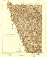
~ Whitaker Peak CA topo map, 1:24000 scale, 7.5 X 7.5 Minute, Historical, 1931, updated 1931
Whitaker Peak, California, USGS topographic map dated 1931.
Includes geographic coordinates (latitude and longitude). This topographic map is suitable for hiking, camping, and exploring, or framing it as a wall map.
Printed on-demand using high resolution imagery, on heavy weight and acid free paper, or alternatively on a variety of synthetic materials.
Topos available on paper, Waterproof, Poly, or Tyvek. Usually shipping rolled, unless combined with other folded maps in one order.
- Product Number: USGS-5658147
- Free digital map download (high-resolution, GeoPDF): Whitaker Peak, California (file size: 11 MB)
- Map Size: please refer to the dimensions of the GeoPDF map above
- Weight (paper map): ca. 55 grams
- Map Type: POD USGS Topographic Map
- Map Series: HTMC
- Map Verison: Historical
- Cell ID: 395901
- Scan ID: 295762
- Imprint Year: 1931
- Survey Year: 1931
- Datum: NAD
- Map Projection: Polyconic
- Advance: Yes
- Map published by United States Geological Survey
- Keywords: Overedge; Nonstandard Press Run
- Map Language: English
- Scanner Resolution: 600 dpi
- Map Cell Name: Whitaker Peak
- Grid size: 7.5 X 7.5 Minute
- Date on map: 1931
- Map Scale: 1:24000
- Geographical region: California, United States
Neighboring Maps:
All neighboring USGS topo maps are available for sale online at a variety of scales.
Spatial coverage:
Topo map Whitaker Peak, California, covers the geographical area associated the following places:
- Devil Canyon Trail - Ellis Apiary Campsite - Whitaker Peak Lookout - Fisher Spring - Turtle Canyon - Jayne Ranch (historical) - Michael Creek - Whitaker Peak - Slayback Camp (historical) - Canton Canyon Trail - Agua Blanca Camp (historical) - Ruby Canyon - Blue Point - Blue Point Campground - Piru Ranger Station (historical) - Kesters Camp - Oak Flat Campground - Pothole Trail - Whitaker Ranch - United States Forest Service Station - Cobblestone Trail - Fustero Point - Oak Flat Spring - Agua Blanca Creek - Canton Canyon - Whitaker Summit - Sharps Canyon - Camp Caula
- Map Area ID: AREA34.634.5-118.8-118.7
- Northwest corner Lat/Long code: USGSNW34.6-118.8
- Northeast corner Lat/Long code: USGSNE34.6-118.7
- Southwest corner Lat/Long code: USGSSW34.5-118.8
- Southeast corner Lat/Long code: USGSSE34.5-118.7
- Northern map edge Latitude: 34.6
- Southern map edge Latitude: 34.5
- Western map edge Longitude: -118.8
- Eastern map edge Longitude: -118.7


