
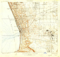
~ Torrance CA topo map, 1:24000 scale, 7.5 X 7.5 Minute, Historical, 1924, updated 1930
Torrance, California, USGS topographic map dated 1924.
Includes geographic coordinates (latitude and longitude). This topographic map is suitable for hiking, camping, and exploring, or framing it as a wall map.
Printed on-demand using high resolution imagery, on heavy weight and acid free paper, or alternatively on a variety of synthetic materials.
Topos available on paper, Waterproof, Poly, or Tyvek. Usually shipping rolled, unless combined with other folded maps in one order.
- Product Number: USGS-5658071
- Free digital map download (high-resolution, GeoPDF): Torrance, California (file size: 10 MB)
- Map Size: please refer to the dimensions of the GeoPDF map above
- Weight (paper map): ca. 55 grams
- Map Type: POD USGS Topographic Map
- Map Series: HTMC
- Map Verison: Historical
- Cell ID: 395993
- Scan ID: 295503
- Imprint Year: 1930
- Survey Year: 1923
- Datum: NAD
- Map Projection: Polyconic
- Map published by United States Geological Survey
- Map Language: English
- Scanner Resolution: 600 dpi
- Map Cell Name: Torrance
- Grid size: 7.5 X 7.5 Minute
- Date on map: 1924
- Map Scale: 1:24000
- Geographical region: California, United States
Neighboring Maps:
All neighboring USGS topo maps are available for sale online at a variety of scales.
Spatial coverage:
Topo map Torrance, California, covers the geographical area associated the following places:
- Redondo Beach - Alondra Park - Ironsides - Hermosa Beach - Moneta - Clifton - Monaco - Walteria - El Nido - Gardena - Southwest Village - Dolanco Junction - Roosevelt - Torrance - La Fresa - Hollywood Riviera - Lawndale - Manhattan Beach - Palos Verdes Estates - Perry - Bridgedale - Dudmore
- Map Area ID: AREA33.933.8-118.4333333-118.3
- Northwest corner Lat/Long code: USGSNW33.9-118.4333333
- Northeast corner Lat/Long code: USGSNE33.9-118.3
- Southwest corner Lat/Long code: USGSSW33.8-118.4333333
- Southeast corner Lat/Long code: USGSSE33.8-118.3
- Northern map edge Latitude: 33.9
- Southern map edge Latitude: 33.8
- Western map edge Longitude: -118.4333333
- Eastern map edge Longitude: -118.3


