
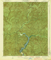
~ Camp Rincon CA topo map, 1:24000 scale, 7.5 X 7.5 Minute, Historical, 1940
Camp Rincon, California, USGS topographic map dated 1940.
Includes geographic coordinates (latitude and longitude). This topographic map is suitable for hiking, camping, and exploring, or framing it as a wall map.
Printed on-demand using high resolution imagery, on heavy weight and acid free paper, or alternatively on a variety of synthetic materials.
Topos available on paper, Waterproof, Poly, or Tyvek. Usually shipping rolled, unless combined with other folded maps in one order.
- Product Number: USGS-5657421
- Free digital map download (high-resolution, GeoPDF): Camp Rincon, California (file size: 13 MB)
- Map Size: please refer to the dimensions of the GeoPDF map above
- Weight (paper map): ca. 55 grams
- Map Type: POD USGS Topographic Map
- Map Series: HTMC
- Map Verison: Historical
- Cell ID: 395973
- Scan ID: 288870
- Woodland Tint: Yes
- Survey Year: 1934
- Datum: NAD
- Map Projection: Polyconic
- Map published by United States Geological Survey
- Map Language: English
- Scanner Resolution: 600 dpi
- Map Cell Name: Camp Rincon
- Grid size: 7.5 X 7.5 Minute
- Date on map: 1940
- Map Scale: 1:24000
- Geographical region: California, United States
Neighboring Maps:
All neighboring USGS topo maps are available for sale online at a variety of scales.
Spatial coverage:
Topo map Camp Rincon, California, covers the geographical area associated the following places:
- Minero Canyon - Coldbrook Creek - San Gabriel Reservoir - Rincon Canyon - Tecolate Plantation - Bear Creek Trail - Area 1 Work Center Forest Service Facility - Graveyard Canyon - Susanna Canyon - Burro Canyon - Chamisal Mesa - Pigeon Target Shooting Area - Wild Honeybee Plantation - Phipps Canyon - Valley of the Moon Plantation - Hoot Owl Flats - East Fork Susanna Canyon - Bichota Canyon - Camp Oak Grove - Lost Canyon - Soldier Creek - Venedo Canyon - Shady Oaks Camp - Alpine Canyon - Smith Mountain - Rockbound Canyon - Horse Canyon Saddle - Cotton Tail Plantation - North Fork San Gabriel River - Fern Springs - Davis Mine - San Gabriel Dam - Upper Bear Trail Camp - Pigeon Ridge - Lower Bear Campground - Persinger Canyon - Burro Shooting Park - West Fork San Gabriel River - Bichota Mesa - Follows Camp - Coldbrook Campground - Polecat Gulch - Browns Gulch - Burro Peak - Maple Canyon - Bear Creek - Cloudburst Canyon - West Fork Roadside Rest - West Fork Bear Creek - Robbs Gulch - Coldbrook Guard Station
- Map Area ID: AREA34.334.2-117.9-117.8
- Northwest corner Lat/Long code: USGSNW34.3-117.9
- Northeast corner Lat/Long code: USGSNE34.3-117.8
- Southwest corner Lat/Long code: USGSSW34.2-117.9
- Southeast corner Lat/Long code: USGSSE34.2-117.8
- Northern map edge Latitude: 34.3
- Southern map edge Latitude: 34.2
- Western map edge Longitude: -117.9
- Eastern map edge Longitude: -117.8


