
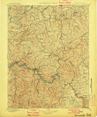
~ Kanawha Falls WV topo map, 1:125000 scale, 30 X 30 Minute, Historical, 1901
Kanawha Falls, West Virginia, USGS topographic map dated 1901.
Includes geographic coordinates (latitude and longitude). This topographic map is suitable for hiking, camping, and exploring, or framing it as a wall map.
Printed on-demand using high resolution imagery, on heavy weight and acid free paper, or alternatively on a variety of synthetic materials.
Topos available on paper, Waterproof, Poly, or Tyvek. Usually shipping rolled, unless combined with other folded maps in one order.
- Product Number: USGS-5638727
- Free digital map download (high-resolution, GeoPDF): Kanawha Falls, West Virginia (file size: 13 MB)
- Map Size: please refer to the dimensions of the GeoPDF map above
- Weight (paper map): ca. 55 grams
- Map Type: POD USGS Topographic Map
- Map Series: HTMC
- Map Verison: Historical
- Cell ID: 395870
- Scan ID: 253986
- Survey Year: 1895
- Datum: Unstated
- Map Projection: Unstated
- Map published by United States Geological Survey
- Map Language: English
- Scanner Resolution: 600 dpi
- Map Cell Name: Kanawha Falls
- Grid size: 30 X 30 Minute
- Date on map: 1901
- Map Scale: 1:125000
- Geographical region: West Virginia, United States
Neighboring Maps:
All neighboring USGS topo maps are available for sale online at a variety of scales.
Spatial coverage:
Topo map Kanawha Falls, West Virginia, covers the geographical area associated the following places:
- Heatherman (historical) - Bachman - Ansted - Crosby - Paxton - Avoca - Quick - Shrewsbury - Vanetta - Morocco (historical) - Albion (historical) - Alta - Clay Junction - Edmond - Adonijah - Youngs Bottom - Warfield - Hollygrove - Boonesborough - Carbon - Cannelton - Hugheston - Triplett - Schrader - Page - Tad - Lockwood - Gamoca - Annfred - Decota - Peters Junction - Kelly Hill - Sand Fork - Marvel - Crescent - Porter - Rosina (historical) - Reamer - Hopewell - Ames - Dundon - Giles - Glasgow - Jamestown (historical) - Chelyan - Powellton - Swiss - KM Junction - Kayford - Falls View - Cinco - Caperton - Greendale - Beauty - Spangler - West Montgomery - Oakland - Boomer - Rouzer - Upper Leatherwood - Kincaid - Cedar Grove - Apgah (historical) - Smithers - Oakton - Elkview - Midway - Longacre - Cabin Creek - Summerlee - Mountain Cove - Deep Water - Quarrier - East Bank - Cotton Hill - Mincar (historical) - Clendenin - Livingston - Lizemores - Grayden - Whittaker - Odessa - Mahan - Cambria - Standard - Dial - Elkhurst - Ramsey - Robson - Kanawha Falls - Wriston - Bomont - Glen Ferris - Leewood - Hansford - Middle Fork - Pond Fork - Romont - Wevaco - Hitop
- Map Area ID: AREA38.538-81.5-81
- Northwest corner Lat/Long code: USGSNW38.5-81.5
- Northeast corner Lat/Long code: USGSNE38.5-81
- Southwest corner Lat/Long code: USGSSW38-81.5
- Southeast corner Lat/Long code: USGSSE38-81
- Northern map edge Latitude: 38.5
- Southern map edge Latitude: 38
- Western map edge Longitude: -81.5
- Eastern map edge Longitude: -81


