
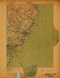
~ York ME topo map, 1:62500 scale, 15 X 15 Minute, Historical, 1920
York, Maine, USGS topographic map dated 1920.
Includes geographic coordinates (latitude and longitude). This topographic map is suitable for hiking, camping, and exploring, or framing it as a wall map.
Printed on-demand using high resolution imagery, on heavy weight and acid free paper, or alternatively on a variety of synthetic materials.
Topos available on paper, Waterproof, Poly, or Tyvek. Usually shipping rolled, unless combined with other folded maps in one order.
- Product Number: USGS-5638121
- Free digital map download (high-resolution, GeoPDF): York, Maine (file size: 5 MB)
- Map Size: please refer to the dimensions of the GeoPDF map above
- Weight (paper map): ca. 55 grams
- Map Type: POD USGS Topographic Map
- Map Series: HTMC
- Map Verison: Historical
- Cell ID: 64799
- Scan ID: 807743
- Survey Year: 1917
- Datum: Unstated
- Map Projection: Unstated
- Map published by United States Geological Survey
- Map published by United States Department of War
- Keywords: Overedge
- Map Language: English
- Scanner Resolution: 508 dpi
- Map Cell Name: York
- Grid size: 15 X 15 Minute
- Date on map: 1920
- Map Scale: 1:62500
- Geographical region: Maine, United States
Neighboring Maps:
All neighboring USGS topo maps are available for sale online at a variety of scales.
Spatial coverage:
Topo map York, Maine, covers the geographical area associated the following places:
- York Heights - Cape Neddick - Chases Pond - Foyes Corner - Sagamore Grove - South Side - Bald Head - Cider Hill - Cain Crest Trailer Park - York Village - New Castle - Cutts Island - Brixham - Scituate - York Corner - Kittery - Briggs Corner - York Beach - Braeburn - Ogunquit - Bedell Crossing - Brixham Lower Corners - Agamenticus Village - Long Beach - Remick Corners - York Cliffs - Emerys Bridge - Kittery Foreside - Beech Ridge - Seavey Island - Concordville - Foristall Corners - Wallis Sands - Kittery Point - Payneton - Shaws Hill - Scotland - Ocean View Village - Fairhill Manor - Walnut Hill - Wayside Trailer Park - Flaggs Trailer Park - Pine Hill - Rye North Beach - Seabury - Shepherds Hill - York Harbor - Clay Hill - Brickyard Landing (historical) - High Pasture - Admiralty Village
- Map Area ID: AREA43.2543-70.75-70.5
- Northwest corner Lat/Long code: USGSNW43.25-70.75
- Northeast corner Lat/Long code: USGSNE43.25-70.5
- Southwest corner Lat/Long code: USGSSW43-70.75
- Southeast corner Lat/Long code: USGSSE43-70.5
- Northern map edge Latitude: 43.25
- Southern map edge Latitude: 43
- Western map edge Longitude: -70.75
- Eastern map edge Longitude: -70.5


