
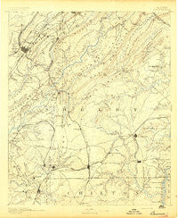
~ Bessemer AL topo map, 1:125000 scale, 30 X 30 Minute, Historical, 1892
Bessemer, Alabama, USGS topographic map dated 1892.
Includes geographic coordinates (latitude and longitude). This topographic map is suitable for hiking, camping, and exploring, or framing it as a wall map.
Printed on-demand using high resolution imagery, on heavy weight and acid free paper, or alternatively on a variety of synthetic materials.
Topos available on paper, Waterproof, Poly, or Tyvek. Usually shipping rolled, unless combined with other folded maps in one order.
- Product Number: USGS-5637597
- Free digital map download (high-resolution, GeoPDF): Bessemer, Alabama (file size: 7 MB)
- Map Size: please refer to the dimensions of the GeoPDF map above
- Weight (paper map): ca. 55 grams
- Map Type: POD USGS Topographic Map
- Map Series: HTMC
- Map Verison: Historical
- Cell ID: 395848
- Scan ID: 305804
- Survey Year: 1888
- Datum: Unstated
- Map Projection: Unstated
- Map published by United States Geological Survey
- Map Language: English
- Scanner Resolution: 600 dpi
- Map Cell Name: Bessemer
- Grid size: 30 X 30 Minute
- Date on map: 1892
- Map Scale: 1:125000
- Geographical region: Alabama, United States
Neighboring Maps:
All neighboring USGS topo maps are available for sale online at a variety of scales.
Spatial coverage:
Topo map Bessemer, Alabama, covers the geographical area associated the following places:
- Kenwood - Country Ridge Estates - Richmond Place - Summit Farm - Glenview - Bessemer Homestead - South Calera - Shady Acres Estates - Crescent Heights - Mossboro - Avalon Park - Hillman Gardens - Dogwood Point - Oxmoor - Loch Haven - Pleasant Grove Estates - Valley Station - Valley Forge - West End - Fourmile - Vineland Park - Ivanhoe - Paramount - Lindseys Crossing - Woodward Junction - Camp Horne - Mayfair - Hudson Grove - Timber Ridge - Hunters Glen (historical) - Sagewood - Stems - Monte-Sano - Lake Purdy - Hueytown Crest - Helena - Pineland Park - Lakeview Estates - Crest Estates - Edgemont - Almont - Westover - Indian Springs Village - Rolling Ridge - Phillips Estates - Deer Springs Estates - Shannon Glen - Heritage Oaks - Hickory Ridge Estates - Dunbarton Oaks - Havenview - Kingdom Crossroads - Huntington Park - Russet Woods - Green Acres - Minooka - Highland Crest - Dolomite - Vestbrook Trace - Wine Ridge - Surrey Hill - Glen Forest - Dargin - Shades Acres - Tangle Creek - Riverwood - Pine Grove Village - Aldrich - Dolonar Junction - Vestwood Hills - Beverly Station - Columbiana - Underwood - Wenonah - Ware - Indian Lake Estates - Chapel Hill - North Highlands - Smith Highlands - Ocampo - Fungo Hollow - Camp Branch - Woodmont - Cahaba Heights - Wisteria Commons - Heatherwood - Genery - Oak Grove Estates - Interurban Heights - Spring Creek - East Saginaw - Homewood - Laurel Estates - Brownville - Ridgecrest - Shades View Estates - Thornhill - Lakeview Park - Brickyard Junction - Patton Chapel
- Map Area ID: AREA33.533-87-86.5
- Northwest corner Lat/Long code: USGSNW33.5-87
- Northeast corner Lat/Long code: USGSNE33.5-86.5
- Southwest corner Lat/Long code: USGSSW33-87
- Southeast corner Lat/Long code: USGSSE33-86.5
- Northern map edge Latitude: 33.5
- Southern map edge Latitude: 33
- Western map edge Longitude: -87
- Eastern map edge Longitude: -86.5


