
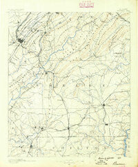
~ Bessemer AL topo map, 1:125000 scale, 30 X 30 Minute, Historical, 1890
Bessemer, Alabama, USGS topographic map dated 1890.
Includes geographic coordinates (latitude and longitude). This topographic map is suitable for hiking, camping, and exploring, or framing it as a wall map.
Printed on-demand using high resolution imagery, on heavy weight and acid free paper, or alternatively on a variety of synthetic materials.
Topos available on paper, Waterproof, Poly, or Tyvek. Usually shipping rolled, unless combined with other folded maps in one order.
- Product Number: USGS-5637595
- Free digital map download (high-resolution, GeoPDF): Bessemer, Alabama (file size: 6 MB)
- Map Size: please refer to the dimensions of the GeoPDF map above
- Weight (paper map): ca. 55 grams
- Map Type: POD USGS Topographic Map
- Map Series: HTMC
- Map Verison: Historical
- Cell ID: 395848
- Scan ID: 305803
- Survey Year: 1888
- Datum: Unstated
- Map Projection: Unstated
- Map published by United States Geological Survey
- Map Language: English
- Scanner Resolution: 600 dpi
- Map Cell Name: Bessemer
- Grid size: 30 X 30 Minute
- Date on map: 1890
- Map Scale: 1:125000
- Geographical region: Alabama, United States
Neighboring Maps:
All neighboring USGS topo maps are available for sale online at a variety of scales.
Spatial coverage:
Topo map Bessemer, Alabama, covers the geographical area associated the following places:
- Twin Bridge - Pleasant Grove - Stems - Shoal Run - Genery - Eden Ridge - Simmsville - Southwood - Gurnee Junction - Aden - Elliotsville - Hollywood - Nelson - Varnons - Shadywood - Tarpley - Hopewell - Martinwood Estates - Saginaw - Vestavia Forest - Lindseys Crossing - Camp Branch - Ridgecrest - Winetka - Hickory Ridge Estates - Coventry - Tangle Creek - Rocky Ridge - Green Acres - Woodward - Mill Run - Highland Forest - Gordon Heights - Lake Purdy - New Village - Edgemoor Estates - Longbrook Estates - Cahaba Cliffs - Vesthaven Estates - Phoenixville - Park Place - Greenwood - Brookview - Moores Crossroads - Aucheucaula (historical) - Timber Ridge - Mallard Point - Lakeview Estates - Montalla Acres - Country Ridge Estates - Southlake - Sky Ranch - Phillips Estates - Fox Haven - Rosemont - Vestridge - Gentilly Forest - Loveless Park - Huntington Park - Chestnut Ridge - East Brighton - Wellington Park - Oak Hills - Ozan - Wine Ridge - Sagewood - Pauls Hill - Hoover - Westbrook Trace - Gurnee - Underwood - Hillsdale - Valdawood - Inverness Cliffs - Hickory Grove - Belwood - Park Courts - Berney Points - Heatherwood - Mission Hills - Oakwood - Edgewood - Dogwood Point - Shady Acres Estates - Bessemer Trailer Park - Harlem Heights - Dolonar - Monte Bello - Germania - Raimund - Valhalla - Woodford - Shannon Glen - Pineland Park - Summit Farm - Westfield - Aldrich - Fox Trace - Belle Haven - Rice
- Map Area ID: AREA33.533-87-86.5
- Northwest corner Lat/Long code: USGSNW33.5-87
- Northeast corner Lat/Long code: USGSNE33.5-86.5
- Southwest corner Lat/Long code: USGSSW33-87
- Southeast corner Lat/Long code: USGSSE33-86.5
- Northern map edge Latitude: 33.5
- Southern map edge Latitude: 33
- Western map edge Longitude: -87
- Eastern map edge Longitude: -86.5


