
~ San Miguel Island East CA topo map, 1:24000 scale, 7.5 X 7.5 Minute, Historical, 1950
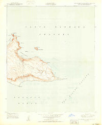
San Miguel Island East, California, USGS topographic map dated 1950.
Includes geographic coordinates (latitude and longitude). This topographic map is suitable for hiking, camping, and exploring, or framing it as a wall map.
Printed on-demand using high resolution imagery, on heavy weight and acid free paper, or alternatively on a variety of synthetic materials.
Topos available on paper, Waterproof, Poly, or Tyvek. Usually shipping rolled, unless combined with other folded maps in one order.
- Product Number: USGS-5631045
- Free digital map download (high-resolution, GeoPDF): San Miguel Island East, California (file size: 6 MB)
- Map Size: please refer to the dimensions of the GeoPDF map above
- Weight (paper map): ca. 55 grams
- Map Type: POD USGS Topographic Map
- Map Series: HTMC
- Map Verison: Historical
- Cell ID: 39679
- Scan ID: 300170
- Aerial Photo Year: 1943
- Field Check Year: 1943
- Datum: NAD27
- Map Projection: Polyconic
- Map published by United States Geological Survey
- Keywords: Nonstandard Press Run
- Map Language: English
- Scanner Resolution: 600 dpi
- Map Cell Name: San Miguel Island East
- Grid size: 7.5 X 7.5 Minute
- Date on map: 1950
- Map Scale: 1:24000
- Geographical region: California, United States
Neighboring Maps:
All neighboring USGS topo maps are available for sale online at a variety of scales.
Spatial coverage:
Topo map San Miguel Island East, California, covers the geographical area associated the following places:
- Bat Rock - Nifty Rock - Judge Rock - Kid Rock - Harris Point - Gull Rock - Middle Rock - Hare Rock - March Rock - Ranch House Flagpole - Crook Point - Cuyler Harbor - San Miguel Passage - Cardwell Point - Clover Rock - Prince Island - Bay Point - Can Rock
- Map Area ID: AREA34.108333333.9833333-120.375-120.25
- Northwest corner Lat/Long code: USGSNW34.1083333-120.375
- Northeast corner Lat/Long code: USGSNE34.1083333-120.25
- Southwest corner Lat/Long code: USGSSW33.9833333-120.375
- Southeast corner Lat/Long code: USGSSE33.9833333-120.25
- Northern map edge Latitude: 34.1083333
- Southern map edge Latitude: 33.9833333
- Western map edge Longitude: -120.375
- Eastern map edge Longitude: -120.25


