
~ Sprague Island FL topo map, 1:24000 scale, 7.5 X 7.5 Minute, Historical, 1982, updated 1984
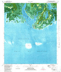
Sprague Island, Florida, USGS topographic map dated 1982.
Includes geographic coordinates (latitude and longitude). This topographic map is suitable for hiking, camping, and exploring, or framing it as a wall map.
Printed on-demand using high resolution imagery, on heavy weight and acid free paper, or alternatively on a variety of synthetic materials.
Topos available on paper, Waterproof, Poly, or Tyvek. Usually shipping rolled, unless combined with other folded maps in one order.
- Product Number: USGS-5628120
- Free digital map download (high-resolution, GeoPDF): Sprague Island, Florida (file size: 20 MB)
- Map Size: please refer to the dimensions of the GeoPDF map above
- Weight (paper map): ca. 55 grams
- Map Type: POD USGS Topographic Map
- Map Series: HTMC
- Map Verison: Historical
- Cell ID: 42570
- Scan ID: 348600
- Imprint Year: 1984
- Woodland Tint: Yes
- Aerial Photo Year: 1978
- Edit Year: 1982
- Field Check Year: 1981
- Datum: NAD27
- Map Projection: Lambert Conformal Conic
- Orthophoto: Map
- Map published by United States Geological Survey
- Map Language: English
- Scanner Resolution: 600 dpi
- Map Cell Name: Sprague Island
- Grid size: 7.5 X 7.5 Minute
- Date on map: 1982
- Map Scale: 1:24000
- Geographical region: Florida, United States
Neighboring Maps:
All neighboring USGS topo maps are available for sale online at a variety of scales.
Spatial coverage:
Topo map Sprague Island, Florida, covers the geographical area associated the following places:
- Oliver Bayou - Graves Creek - Four Mile Creek - Little Pass - Haulover Creek - Pelican Point - Apalachee Bay - Middle Creek - Gibbs Island - Indian Pass - Little Denham Bayou - Johns Island - Big Cove - Big Pass - Indian Point - Picnic Pond - Four Mile Point - Stony Bayou Pool - Minnie Cove - Mounds Pond - Horns Creek - Africa Bayou - Slough Island - Shine Creek - Bird Racks - Gibbs Pond - Johns Cove - Kitchen Cove - East River - Johns Creek - Flat Creek - Register Bayou - Sand Cove - Steward Bayou - Stony Bayou - Little West Bayou - Denham Bayou - Mounds Pool - East Goose Creek - Little Pass Island - Mound Lookout Tower - Spectacle Pond - Saint Marks National Wildlife Refuge - Sprague Point - Sprague Island - Saint Marks Light - Saint Marks River - Boggy Bayou - Headquarters Pond - Big Pass Island - Big West Bayou - Rock Creek - Lighthouse Pool
- Map Area ID: AREA30.12530-84.25-84.125
- Northwest corner Lat/Long code: USGSNW30.125-84.25
- Northeast corner Lat/Long code: USGSNE30.125-84.125
- Southwest corner Lat/Long code: USGSSW30-84.25
- Southeast corner Lat/Long code: USGSSE30-84.125
- Northern map edge Latitude: 30.125
- Southern map edge Latitude: 30
- Western map edge Longitude: -84.25
- Eastern map edge Longitude: -84.125


