
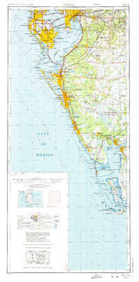
~ Tampa FL topo map, 1:250000 scale, 2 X 1 Degree, Historical, 1972, updated 1974
Tampa, Florida, USGS topographic map dated 1972.
Includes geographic coordinates (latitude and longitude). This topographic map is suitable for hiking, camping, and exploring, or framing it as a wall map.
Printed on-demand using high resolution imagery, on heavy weight and acid free paper, or alternatively on a variety of synthetic materials.
Topos available on paper, Waterproof, Poly, or Tyvek. Usually shipping rolled, unless combined with other folded maps in one order.
- Product Number: USGS-5621818
- Free digital map download (high-resolution, GeoPDF): Tampa, Florida (file size: 16 MB)
- Map Size: please refer to the dimensions of the GeoPDF map above
- Weight (paper map): ca. 55 grams
- Map Type: POD USGS Topographic Map
- Map Series: HTMC
- Map Verison: Historical
- Cell ID: 320751
- Scan ID: 348790
- Imprint Year: 1974
- Woodland Tint: Yes
- Aerial Photo Year: 1972
- Edit Year: 1972
- Datum: Unstated
- Map Projection: Transverse Mercator
- Map published by United States Geological Survey
- Map Language: English
- Scanner Resolution: 600 dpi
- Map Cell Name: Tampa
- Grid size: 2 X 1 Degree
- Date on map: 1972
- Map Scale: 1:250000
- Geographical region: Florida, United States
Neighboring Maps:
All neighboring USGS topo maps are available for sale online at a variety of scales.
Spatial coverage:
Topo map Tampa, Florida, covers the geographical area associated the following places:
- Brandon View Estates - Barrington Oaks East - Stelling Village - Oak Villa - Shady Oaks - Regency Cove - Messick Acres - Bealsville - Lawndale - Belvedere Acres - Askew - East Suwanee Heights - Bridgeview Estates - Lithia Estates - Rolling Acres - Jenkins - Keysville Estates - Wheeler Groves - The Winds - Nehaul - La Vergne - Roberts - West Naples - Belleair Shores - Bayhaven - Pershing Park - Grand View - Winifred Park - Caruthers - Porter Acres - Pearson Estates - Capitano - Walden Lake Fairway Estates - Roberts - Howard Terrace - Palm Way - Murdock - Al Mar - Brandon Woodlands - North Oaks Manor - Drakes Place - Park Place of East Tampa - Deep Creek - Belleair Beach - Kings Lake - Orange Heights - Duncans Mobile Home Park - Boyette Springs - Valrico Forest - Fairfield - Uleta - Pirate Harbor - Creek View - Covewood - Highland Creek - Peppermill at Providence Lakes - Hancock - Reina Victoria - Schley - Harbour Heights - Venice - La Carbayera - Tradewinds - Knoxville Acres - Andalucia - Oak Shadows - Allens - Plantation - Boaz - La Belle - Estates at Limona Woods - Freedom Village - Durrance Palm River Estates - Shell Point Estates - Hancocks Acres - Alma Heights - Bloomingdale - Nebraska Heights - Madsen Court - Nichols - West Suwanee Heights - Moody Heights - Wood Lynne - Doe Creek Reserve - Nokomis Beach - Bailey Hall - Symmes Grove - Camden Oaks - Dranefield Mobile Home Park - Matlacha Isles - Drew Park - Rubia - Sand Ridge Estates - Cones - Osborne Oaks - Bradenton - Saint Cloud Oaks - Oakwood Estates - The Hammock - La Casa
- Map Area ID: AREA2826-83-82
- Northwest corner Lat/Long code: USGSNW28-83
- Northeast corner Lat/Long code: USGSNE28-82
- Southwest corner Lat/Long code: USGSSW26-83
- Southeast corner Lat/Long code: USGSSE26-82
- Northern map edge Latitude: 28
- Southern map edge Latitude: 26
- Western map edge Longitude: -83
- Eastern map edge Longitude: -82


