
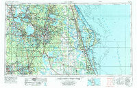
~ Orlando FL topo map, 1:250000 scale, 1 X 2 Degree, Historical, 1955, updated 1975
Orlando, Florida, USGS topographic map dated 1955.
Includes geographic coordinates (latitude and longitude). This topographic map is suitable for hiking, camping, and exploring, or framing it as a wall map.
Printed on-demand using high resolution imagery, on heavy weight and acid free paper, or alternatively on a variety of synthetic materials.
Topos available on paper, Waterproof, Poly, or Tyvek. Usually shipping rolled, unless combined with other folded maps in one order.
- Product Number: USGS-5621760
- Free digital map download (high-resolution, GeoPDF): Orlando, Florida (file size: 21 MB)
- Map Size: please refer to the dimensions of the GeoPDF map above
- Weight (paper map): ca. 55 grams
- Map Type: POD USGS Topographic Map
- Map Series: HTMC
- Map Verison: Historical
- Cell ID: 68950
- Scan ID: 347863
- Imprint Year: 1975
- Woodland Tint: Yes
- Aerial Photo Year: 1972
- Edit Year: 1972
- Field Check Year: 1955
- Datum: Unstated
- Map Projection: Transverse Mercator
- Map published by: Military, Other
- Map Language: English
- Scanner Resolution: 600 dpi
- Map Cell Name: Orlando
- Grid size: 1 X 2 Degree
- Date on map: 1955
- Map Scale: 1:250000
- Geographical region: Florida, United States
Neighboring Maps:
All neighboring USGS topo maps are available for sale online at a variety of scales.
Spatial coverage:
Topo map Orlando, Florida, covers the geographical area associated the following places:
- King Street Mobile Home Community - Beacon Hill Colony Mobile Home Park - Silver Star Village Mobile Home Park - Zellwood - Lamplighter Mobile Park - Lake Bonny Mobile Home Park - Oak Haven Mobile Home Park - Sundance Mobile Home Park - Woodland Oaks Mobile Home Park - Fatio - Skytop - Eloise Woods - Oak Point Mobile Park - Lake Jem - Helens Mobile Home Park - Tuscannoga - Lake Deer Mobile Hamlet - Leesburg - Grand Island Mobile Home Park - Pine Forest Mobile Home Park - Sorrento - Camelot Village Mobile Home Park - Confer - Palamar Trailer Park - Oak Tree Park - Covington Estates Mobile Home Park - Kolokee - Rosemont - Hillside Mobile Home Park - Riverest Mobile Home Community - Valley Mobile Home Park - Lakes of Melbourne Mobile Home Park - Twin Palms Trailer Park - Buena Vista - Lake Buena Vista - Celebration - Sharpes - Hyde Park Mobile Home Park - Emerald Lakes Mobile Village - Hoosier Park Mobile Home Park - Plymouth - Tamarack East Mobile Home Park - Intercoastal Estates Mobile Home Park - Kings Trailer Park - Victoria Gardens Mobile Home Park - Bahia Subdivision - Pinewood Mobile Village - Eagle One Mobile Home Park - Grant Estates Mobile Home Park - Lockhart - Whippoorwill Mobile Home Park - Harmony - Lake Haven Mobile Home Park - Oak Meadows Mobile Home Park - Orange Blossom Trailer Park - Lemon Bluff - Hiawatha Mobile Home Park - Peak Haven Mobile Home Park - Oak Manor Mobile Home Park - Howie In The Hills - Whispering Pines Mobile Home Park - Wilson Place - Belle Isle Oaks Mobile Home Park - Azalea Park - Tuskawilla Trails Mobile Home Park - Jerico Mobile Home Park - Whispering Oaks Mobile Home Community - Big Lake Village Mobile Home Park - Manatee Hammock Park Mobile Home Park - Lake Drive Mobile Home Park - Wekiwa Springs - Killarney Mobile Home Park - Merritt Island Village Resort Mobile Home Park - Clifton - Carpenter Road Mobile Home Park - Pinewood Mobile Home Park - Tangelo Park - Hacienda Village Mobile Home Park - Fairview Mobile Court - Lake Helen Villa Mobile Home Park - Sandford's Mobile Home Park - Audubon - Providence - Maytown - Molokai Cooperative Mobile Home Park - Fullers - Brightwood Manor Trailer Park - Apopka - Poyner - Port Saint John - Sunnyside - Country Life I Mobile Home Park - Kissimmee - Wiley - Paola - Blue Springs Landing - Whites Landing - Bethany Mobile Home Park - Bethune Beach - The Hills Mobile Home Park
- Map Area ID: AREA2928-82-80
- Northwest corner Lat/Long code: USGSNW29-82
- Northeast corner Lat/Long code: USGSNE29-80
- Southwest corner Lat/Long code: USGSSW28-82
- Southeast corner Lat/Long code: USGSSE28-80
- Northern map edge Latitude: 29
- Southern map edge Latitude: 28
- Western map edge Longitude: -82
- Eastern map edge Longitude: -80


