
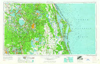
~ Orlando FL topo map, 1:250000 scale, 1 X 2 Degree, Historical, 1962, updated 1962
Orlando, Florida, USGS topographic map dated 1962.
Includes geographic coordinates (latitude and longitude). This topographic map is suitable for hiking, camping, and exploring, or framing it as a wall map.
Printed on-demand using high resolution imagery, on heavy weight and acid free paper, or alternatively on a variety of synthetic materials.
Topos available on paper, Waterproof, Poly, or Tyvek. Usually shipping rolled, unless combined with other folded maps in one order.
- Product Number: USGS-5621756
- Free digital map download (high-resolution, GeoPDF): Orlando, Florida (file size: 16 MB)
- Map Size: please refer to the dimensions of the GeoPDF map above
- Weight (paper map): ca. 55 grams
- Map Type: POD USGS Topographic Map
- Map Series: HTMC
- Map Verison: Historical
- Cell ID: 68950
- Scan ID: 347861
- Imprint Year: 1962
- Woodland Tint: Yes
- Edit Year: 1962
- Field Check Year: 1955
- Datum: Unstated
- Map Projection: Transverse Mercator
- Map published by United States Geological Survey
- Map published by United States Army Corps of Engineers
- Map published by United States Army
- Map Language: English
- Scanner Resolution: 600 dpi
- Map Cell Name: Orlando
- Grid size: 1 X 2 Degree
- Date on map: 1962
- Map Scale: 1:250000
- Geographical region: Florida, United States
Neighboring Maps:
All neighboring USGS topo maps are available for sale online at a variety of scales.
Spatial coverage:
Topo map Orlando, Florida, covers the geographical area associated the following places:
- Sherman Park - Green Pond - Orange Tree Mobile Home Park - Osteen - Beacon Terrace Mobile Home Park - 2505 Tanglewood Street Mobile Home Park - Taft - Winter Park - Kings and Queens Mobile Home Park - Footman - Brooks Mobile Home Park - Silver Star Village Mobile Home Park - Sandpiper Mobile Home Manor - Canal Addition (historical) - Sunnyside - Markham - Edgewater Mobile Home Park - Clair Mar Mobile Home Park - Haines City - Poinsettia Park - Cozy Cove Mobile Home Park - Tan Tara Mobile Home Park - Groveland Mobile Home Park - Lamplighter Village III Mobile Home Park - Peak Haven Mobile Home Park - River Forest Mobile Home Park - Confer - Maitland - Tavares - Emerald Lake Mobile Home Park - Hillcrest Mobile Home Village - Eagle Trailer Park - Eva - Ferndale - Carriage Cove Mobile Home Park - Lakeshore Landings Mobile Home Park - Indian Oaks Trailer Park - Manatee Hammock Park Mobile Home Park - Sanlanta - Barton Lake Mobile Home Park - Slones Ridge - Bahia Subdivision - Twin Oaks Mobile Home Park - Forest Village Mobile Park - Flamingo - Cocoa Palms Mobile Home Park - Clay Island - June Park - Kolokee - El Punto Lake Mobile Home Park - Big Oak Trailer Park - The Cove Mobile Home Park - The Retreat at Twin Lakes - Palm Bay - Lynchburg - Weirsdale - Johnson Rainbow Trailer Park - Alderene Park - Kissimmee Gardens Mobile Home Park - Lake Griffin Harbor Mobile Home Park - Peachtree Park Mobile Home Park - United Trailer Park - Wilsons Trailer Park - Hacienda Village Mobile Home Park - Yalaha - King Street Mobile Home Community - Bonfire Mobile Home Village - Runnymede - Byrd Plaza Mobile Home Park - Hilltop Mobile Home Park - Jay Jay - Lockhart - Dreamworld - Georgetowne Mobile Manor - Farmton - Lincoln Heights - Grant Estates Mobile Home Park - Oak Hill Mobile Home Park - Sunlake Estates Mobile Park - J and M Mobile Home Park - Center Hill - Edgewater Junction - Holiday Village Travel Park - Indian River Trailer Park - Boden - Ariel - Davis Island Mobile Home Park - Oak Meadows Mobile Home Park - Lakeside Mobile Home Court - Tangelo Park - Orangewood Village Mobile Home Park - Haines Haven Mobile Park - Saint Cloud - Florida Hills - Lamplighter Mobile Home Park - Valdez - Palm Shores - Montverde - Black Bear Mobile Home Park - Bassville Park
- Map Area ID: AREA2928-82-80
- Northwest corner Lat/Long code: USGSNW29-82
- Northeast corner Lat/Long code: USGSNE29-80
- Southwest corner Lat/Long code: USGSSW28-82
- Southeast corner Lat/Long code: USGSSE28-80
- Northern map edge Latitude: 29
- Southern map edge Latitude: 28
- Western map edge Longitude: -82
- Eastern map edge Longitude: -80


