
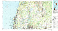
~ Tarpon Springs FL topo map, 1:100000 scale, 30 X 60 Minute, Historical, 1978, updated 1982
Tarpon Springs, Florida, USGS topographic map dated 1978.
Includes geographic coordinates (latitude and longitude). This topographic map is suitable for hiking, camping, and exploring, or framing it as a wall map.
Printed on-demand using high resolution imagery, on heavy weight and acid free paper, or alternatively on a variety of synthetic materials.
Topos available on paper, Waterproof, Poly, or Tyvek. Usually shipping rolled, unless combined with other folded maps in one order.
- Product Number: USGS-5621680
- Free digital map download (high-resolution, GeoPDF): Tarpon Springs, Florida (file size: 29 MB)
- Map Size: please refer to the dimensions of the GeoPDF map above
- Weight (paper map): ca. 55 grams
- Map Type: POD USGS Topographic Map
- Map Series: HTMC
- Map Verison: Historical
- Cell ID: 68440
- Scan ID: 348802
- Imprint Year: 1982
- Woodland Tint: Yes
- Aerial Photo Year: 1977
- Edit Year: 1978
- Datum: NAD27
- Map Projection: Universal Transverse Mercator
- Map published by United States Geological Survey
- Map Language: English
- Scanner Resolution: 600 dpi
- Map Cell Name: Tarpon Springs
- Grid size: 30 X 60 Minute
- Date on map: 1978
- Map Scale: 1:100000
- Geographical region: Florida, United States
Neighboring Maps:
All neighboring USGS topo maps are available for sale online at a variety of scales.
Spatial coverage:
Topo map Tarpon Springs, Florida, covers the geographical area associated the following places:
- Enclave of Carrollwood - Lake Keen - Dolce Vita - Watrous Gardens - Merrin Acres - Le Clare Shores - Lake Carroll Estates - Renaissance Estates - Temple Highlands - Davies Country Acres - Riverleaf - Rau Acres - East End Place - Estates of Rock Lake - Endres - Miralago Estates - East Point - Temple Terrace Riverside - Oak Path - Manor Hills - Northdale - Turtle Crossing - Jane Terrace - Mark Hall Acres - Tapps River Breeze - Keeters - River Run - Keystone Park - Beacon Lakes - Rocky Pond - Magnolias at Dawn - Beacon Square - Bellamy - Rolling Terrace - Palm Heights - Four Pine Estates - Bougenvista - Marriott - Hounds Run - Croteau - Northwood Village - Oakland Heights - Frances Arbor Villas - Sugarwood Grove - Menendez Landings - O'Hara - Roseland Park - Antioch Place - Mason Estates - Mingo Manor - Rose Harbor - Westmoreland Place - Seminole Lake Estates - Mohr Loop - Trilby - Farkas Estates - Carr Drive - Loyce - Cherry Creek - Silver Oaks - Sunny Slopes - Temple Terrace Estates - Kingsway - Money Estates - Keystone Manor - Lindawoods - Strawberry Square - Blanton - Ventana - Golden Park - Magdalene Forest - Lucy Dell - Bristol Park - East Village - Koostra - West Meadows - Langshire Village - Saint Joseph - Magnolia Manors - Lynnette Estates - Erma - Riverhills Park - Parkwood Village - C And B Estates - Warrington Green - Lindow Estates - Manor Heights - Four Seasons - Estates at Parsons Pointe - Sedona de Avila - Glen Ellen Village - Idle Grove Park - Dormany Oaks - Cedarwood - Ham Oaks - Small Farms - Jones Estates - Marshall Heights - Spring Hill - Oak Knoll
- Map Area ID: AREA28.528-83-82
- Northwest corner Lat/Long code: USGSNW28.5-83
- Northeast corner Lat/Long code: USGSNE28.5-82
- Southwest corner Lat/Long code: USGSSW28-83
- Southeast corner Lat/Long code: USGSSE28-82
- Northern map edge Latitude: 28.5
- Southern map edge Latitude: 28
- Western map edge Longitude: -83
- Eastern map edge Longitude: -82


