
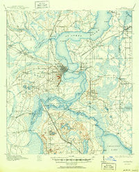
~ Palatka FL topo map, 1:62500 scale, 15 X 15 Minute, Historical, 1915, updated 1950
Palatka, Florida, USGS topographic map dated 1915.
Includes geographic coordinates (latitude and longitude). This topographic map is suitable for hiking, camping, and exploring, or framing it as a wall map.
Printed on-demand using high resolution imagery, on heavy weight and acid free paper, or alternatively on a variety of synthetic materials.
Topos available on paper, Waterproof, Poly, or Tyvek. Usually shipping rolled, unless combined with other folded maps in one order.
- Product Number: USGS-5621438
- Free digital map download (high-resolution, GeoPDF): Palatka, Florida (file size: 8 MB)
- Map Size: please refer to the dimensions of the GeoPDF map above
- Weight (paper map): ca. 55 grams
- Map Type: POD USGS Topographic Map
- Map Series: HTMC
- Map Verison: Historical
- Cell ID: 60711
- Scan ID: 347954
- Imprint Year: 1950
- Survey Year: 1912
- Datum: NAD
- Map Projection: Polyconic
- Map published by United States Geological Survey
- Map Language: English
- Scanner Resolution: 600 dpi
- Map Cell Name: Palatka
- Grid size: 15 X 15 Minute
- Date on map: 1915
- Map Scale: 1:62500
- Geographical region: Florida, United States
Neighboring Maps:
All neighboring USGS topo maps are available for sale online at a variety of scales.
Spatial coverage:
Topo map Palatka, Florida, covers the geographical area associated the following places:
- Azalea Mobile Home Park South - Warwick Trailer Park - Rice Creek - Teasdale - Tall Timbers Mobile Home Park - Hastings - Sisco - Grand View Grove - Sutherlands Still - Possum Bluff - Buffalo Bluff - Cypress Point - River Villas Manufactured Home Park - Grubbs Mobile Home Club - Bainbridge Road Mobile Home Park - Fairview - Springside Park - Azalea Mobile Home Park North - Westover Mobile Home Park - Peniel - Francis - Okawahathako (historical) - Federal Point - Springside - Bardin - Satsuma - Yelvington - Silver Lake Oaks Mobile Home Village - Pomona Park - April Oaks Mobile Home Park - Rollestown (historical) - East Palatka - Villa Farms Mobile Home Park - San Mateo - Watts Trailer Park - Saratoga - Rivercrest Trailer Park - Grandview - Ezra's Landing Mobile Home Park - Ryan's Trailer Park - Isabellas Place Mobile Home Park - Nashua - Palatka - Oaks Landing Mobile Home Park - Pecan - Lundy - Alhambra Mobile Home Community - Orange Mills - Seminole Grove - Patersonville
- Map Area ID: AREA29.7529.5-81.75-81.5
- Northwest corner Lat/Long code: USGSNW29.75-81.75
- Northeast corner Lat/Long code: USGSNE29.75-81.5
- Southwest corner Lat/Long code: USGSSW29.5-81.75
- Southeast corner Lat/Long code: USGSSE29.5-81.5
- Northern map edge Latitude: 29.75
- Southern map edge Latitude: 29.5
- Western map edge Longitude: -81.75
- Eastern map edge Longitude: -81.5


