
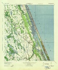
~ Ormond FL topo map, 1:62500 scale, 15 X 15 Minute, Historical, 1944
Ormond, Florida, USGS topographic map dated 1944.
Includes geographic coordinates (latitude and longitude). This topographic map is suitable for hiking, camping, and exploring, or framing it as a wall map.
Printed on-demand using high resolution imagery, on heavy weight and acid free paper, or alternatively on a variety of synthetic materials.
Topos available on paper, Waterproof, Poly, or Tyvek. Usually shipping rolled, unless combined with other folded maps in one order.
- Product Number: USGS-5621424
- Free digital map download (high-resolution, GeoPDF): Ormond, Florida (file size: 11 MB)
- Map Size: please refer to the dimensions of the GeoPDF map above
- Weight (paper map): ca. 55 grams
- Map Type: POD USGS Topographic Map
- Map Series: HTMC
- Map Verison: Historical
- Cell ID: 60602
- Scan ID: 347878
- Woodland Tint: Yes
- Aerial Photo Year: 1943
- Survey Year: 1937
- Datum: NAD27
- Map Projection: Polyconic
- Map published by United States Army Corps of Engineers
- Map published by United States Army
- Map published by United States Department of War
- Map Language: English
- Scanner Resolution: 600 dpi
- Map Cell Name: Ormond
- Grid size: 15 X 15 Minute
- Date on map: 1944
- Map Scale: 1:62500
- Geographical region: Florida, United States
Neighboring Maps:
All neighboring USGS topo maps are available for sale online at a variety of scales.
Spatial coverage:
Topo map Ormond, Florida, covers the geographical area associated the following places:
- Sweetgum Mobile Home Park - Westwood Mobile Home Park - Favoretta - Ormond Beach - Perrywood Villa Mobile Home Community - Plantation Oaks Mobile Home Park - Shangri La Mobile Villa - Arroyo Mobile Home Park - Bear Creek Mobile Home Park - Shady Oaks Mobile Home Park - Ormond-by-the-Sea - Ridgecrest Mobile Home Park - Flagler Beach - Dupont - Ortona - El Ray Trailer Park - Korona - Tomoka Estates - Granada Mobile Home Park - Life Mobile Home Park - Holiday Village Mobile Home Park - Palm Terrace Mobile Manor - Kurras Mobile Village - Ellinor Village - National Gardens - Camelot Mobile Home Park - Mound Grove - Flagler Beach Trailer Park
- Map Area ID: AREA29.529.25-81.25-81
- Northwest corner Lat/Long code: USGSNW29.5-81.25
- Northeast corner Lat/Long code: USGSNE29.5-81
- Southwest corner Lat/Long code: USGSSW29.25-81.25
- Southeast corner Lat/Long code: USGSSE29.25-81
- Northern map edge Latitude: 29.5
- Southern map edge Latitude: 29.25
- Western map edge Longitude: -81.25
- Eastern map edge Longitude: -81


