
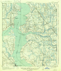
~ Orange Park FL topo map, 1:62500 scale, 15 X 15 Minute, Historical, 1918, updated 1942
Orange Park, Florida, USGS topographic map dated 1918.
Includes geographic coordinates (latitude and longitude). This topographic map is suitable for hiking, camping, and exploring, or framing it as a wall map.
Printed on-demand using high resolution imagery, on heavy weight and acid free paper, or alternatively on a variety of synthetic materials.
Topos available on paper, Waterproof, Poly, or Tyvek. Usually shipping rolled, unless combined with other folded maps in one order.
- Product Number: USGS-5621420
- Free digital map download (high-resolution, GeoPDF): Orange Park, Florida (file size: 7 MB)
- Map Size: please refer to the dimensions of the GeoPDF map above
- Weight (paper map): ca. 55 grams
- Map Type: POD USGS Topographic Map
- Map Series: HTMC
- Map Verison: Historical
- Cell ID: 60575
- Scan ID: 347846
- Imprint Year: 1942
- Survey Year: 1917
- Datum: NAD
- Map Projection: Polyconic
- Map published by United States Geological Survey
- Map published by United States Army Corps of Engineers
- Map published by United States Department of War
- Map Language: English
- Scanner Resolution: 600 dpi
- Map Cell Name: Orange Park
- Grid size: 15 X 15 Minute
- Date on map: 1918
- Map Scale: 1:62500
- Geographical region: Florida, United States
Neighboring Maps:
All neighboring USGS topo maps are available for sale online at a variety of scales.
Spatial coverage:
Topo map Orange Park, Florida, covers the geographical area associated the following places:
- Thunderbird Mobile Home Park - Venetia Terrace - Amity Anchorage Mobile Home Park - Greenland - Orangedale - Loretto - Whites Ford - Hibernia - Pine Bluff - Blacks Ford - Venetia - Trailer Terrace Mobile Home Park - Russell - San Diego Salamototo (historical) - Orange Park - Switzerland - Rhondas Trailer Park - East Mandarin - Bellair - Dewey Park - Holly Point - Yukon - Magnolia Springs - Plummers - Camp Echockotee - Wesconnett - Continental Village Mobile Home Park - Stockade - Sampson - Neilhurst - Mandarin - Fellowship Park - Meadowbrook Terrace - Laurel Grove - Orange Park North Mobile Home Community - Deerwood Club - Yukon Station Mobile Home Park - Fruit Cove - Beauclerc - Beauclerc Gardens - Marshall Plantation (historical) - Ortega Village Manufactured Home Community - Bayard - Wesley Manor Retirement Village - Three Seasons Mobile Home Village - Americana Mobile Home Park - San Jose - Goodbys - Royal Court Mobile Home - Seaboard Mobile Home Park - Sunbeam
- Map Area ID: AREA30.2530-81.75-81.5
- Northwest corner Lat/Long code: USGSNW30.25-81.75
- Northeast corner Lat/Long code: USGSNE30.25-81.5
- Southwest corner Lat/Long code: USGSSW30-81.75
- Southeast corner Lat/Long code: USGSSE30-81.5
- Northern map edge Latitude: 30.25
- Southern map edge Latitude: 30
- Western map edge Longitude: -81.75
- Eastern map edge Longitude: -81.5


