
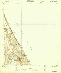
~ Port Orange FL topo map, 1:48000 scale, 15 X 15 Minute, Historical, 1937
Port Orange, Florida, USGS topographic map dated 1937.
Includes geographic coordinates (latitude and longitude). This topographic map is suitable for hiking, camping, and exploring, or framing it as a wall map.
Printed on-demand using high resolution imagery, on heavy weight and acid free paper, or alternatively on a variety of synthetic materials.
Topos available on paper, Waterproof, Poly, or Tyvek. Usually shipping rolled, unless combined with other folded maps in one order.
- Product Number: USGS-5621094
- Free digital map download (high-resolution, GeoPDF): Port Orange, Florida (file size: 7 MB)
- Map Size: please refer to the dimensions of the GeoPDF map above
- Weight (paper map): ca. 55 grams
- Map Type: POD USGS Topographic Map
- Map Series: HTMC
- Map Verison: Historical
- Cell ID: 61201
- Scan ID: 348187
- Survey Year: 1937
- Datum: NAD27
- Map Projection: Polyconic
- Advance: Yes
- Keywords: Nonstandard Press Run
- Map Language: English
- Scanner Resolution: 600 dpi
- Map Cell Name: Port Orange
- Grid size: 15 X 15 Minute
- Date on map: 1937
- Map Scale: 1:48000
- Geographical region: Florida, United States
Neighboring Maps:
All neighboring USGS topo maps are available for sale online at a variety of scales.
Spatial coverage:
Topo map Port Orange, Florida, covers the geographical area associated the following places:
- Halifax Trailer Park - Ponce Park - Tanglewood Mobile Estates - Harbor Oaks Trailer Park - Waters Edge Mobile Home Park - Port Orange - Halifax Estates - Mission City - Live Oak Mobile Village - Rose Bay Trailer Park - Daytona Beach Shores - Redland Estates Mobile Home Community - White Bird Mobile Home Park - Cozy Trailer Park - Parkwood Manufactured Home Community - New Smyrna (historical) - Treasure Isle Estates Mobile Home Park - Maplewood Mobile Estates - Glencoe - New Smyrna Beach - Isleboro - Allandale Mobile Home Park - Blue Skies Mobile Home Village - Briarwood Mobile Estates - Seahorse Mobile Home Park - Riverside Mobile Home Park - Ponce Inlet - Lutz Mobile Home Park - Quail Hollow Mobile Home Park - Gold Rock Park Mobile Home Park - Ocean Aire Estates Mobile Home Park - Suwannee Mobile Home Park - Shrocks Trailer Park - Harbor Oaks - Wilbur-by-the-Sea - Sugar Mill Mobile Home Park - Bayview Trailer Park - Palm Shores Mobile Home Park - Sugar Mill Ruins Travel Park - Sugar Mill Estates - Allandale
- Map Area ID: AREA29.2529-81-80.75
- Northwest corner Lat/Long code: USGSNW29.25-81
- Northeast corner Lat/Long code: USGSNE29.25-80.75
- Southwest corner Lat/Long code: USGSSW29-81
- Southeast corner Lat/Long code: USGSSE29-80.75
- Northern map edge Latitude: 29.25
- Southern map edge Latitude: 29
- Western map edge Longitude: -81
- Eastern map edge Longitude: -80.75


