
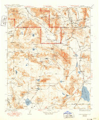
~ Avawatz Mountains CA topo map, 1:250000 scale, 1 X 1 Degree, Historical, 1933, updated 1950
Avawatz Mountains, California, USGS topographic map dated 1933.
Includes geographic coordinates (latitude and longitude). This topographic map is suitable for hiking, camping, and exploring, or framing it as a wall map.
Printed on-demand using high resolution imagery, on heavy weight and acid free paper, or alternatively on a variety of synthetic materials.
Topos available on paper, Waterproof, Poly, or Tyvek. Usually shipping rolled, unless combined with other folded maps in one order.
- Product Number: USGS-5618396
- Free digital map download (high-resolution, GeoPDF): Avawatz Mountains, California (file size: 9 MB)
- Map Size: please refer to the dimensions of the GeoPDF map above
- Weight (paper map): ca. 55 grams
- Map Type: POD USGS Topographic Map
- Map Series: HTMC
- Map Verison: Historical
- Cell ID: 322220
- Scan ID: 299725
- Imprint Year: 1950
- Survey Year: 1930
- Datum: NAD
- Map Projection: Polyconic
- Map published by United States Geological Survey
- Map Language: English
- Scanner Resolution: 600 dpi
- Map Cell Name: Trona E
- Grid size: 1 X 1 Degree
- Date on map: 1933
- Map Scale: 1:250000
- Geographical region: California, United States
Neighboring Maps:
All neighboring USGS topo maps are available for sale online at a variety of scales.
Spatial coverage:
Topo map Avawatz Mountains, California, covers the geographical area associated the following places:
- Mojave Base - Dunn - Crucero - Goldstone - Tecopa - Ashford Mill (historical) - Renoville - Baker - Midway - Zzyzx - Basin - Cronese Valley - Acme (historical) - King (historical) - Shoshone - Talc (historical) - Echo - Beacon Station - Ashford Junction - Sperry - Fort Irwin - Cronise (historical) - Apollo - Venus - Belfast (historical) - New Dunn - Dumont (historical) - Mars - Balch - Valjean - Baxter (historical) - Afton
- Map Area ID: AREA3635-117-116
- Northwest corner Lat/Long code: USGSNW36-117
- Northeast corner Lat/Long code: USGSNE36-116
- Southwest corner Lat/Long code: USGSSW35-117
- Southeast corner Lat/Long code: USGSSE35-116
- Northern map edge Latitude: 36
- Southern map edge Latitude: 35
- Western map edge Longitude: -117
- Eastern map edge Longitude: -116


