
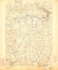
~ Kent RI topo map, 1:62500 scale, 15 X 15 Minute, Historical, 1890
Kent, Rhode Island, USGS topographic map dated 1890.
Includes geographic coordinates (latitude and longitude). This topographic map is suitable for hiking, camping, and exploring, or framing it as a wall map.
Printed on-demand using high resolution imagery, on heavy weight and acid free paper, or alternatively on a variety of synthetic materials.
Topos available on paper, Waterproof, Poly, or Tyvek. Usually shipping rolled, unless combined with other folded maps in one order.
- Product Number: USGS-5604532
- Free digital map download (high-resolution, GeoPDF): Kent, Rhode Island (file size: 8 MB)
- Map Size: please refer to the dimensions of the GeoPDF map above
- Weight (paper map): ca. 55 grams
- Map Type: POD USGS Topographic Map
- Map Series: HTMC
- Map Verison: Historical
- Cell ID: 56104
- Scan ID: 353494
- Survey Year: 1888
- Datum: Unstated
- Map Projection: Unstated
- Map published by United States Geological Survey
- Map Language: English
- Scanner Resolution: 600 dpi
- Map Cell Name: Kent
- Grid size: 15 X 15 Minute
- Date on map: 1890
- Map Scale: 1:62500
- Geographical region: Rhode Island, United States
Neighboring Maps:
All neighboring USGS topo maps are available for sale online at a variety of scales.
Spatial coverage:
Topo map Kent, Rhode Island, covers the geographical area associated the following places:
- Vernon - Birch Hill (historical) - Spring Lake - Exeter - Ike Shippee Corner - Hope Valley - Jackson - Usquepaug - Lippitt - Hope - Liberty - Wyoming - Anthony - Coventry - River Point - Crompton - Fisherville - Horn Heap - Places Corner - Harris - Locustville - Tripps Corner - Cranstons Corner (historical) - Tarbox Corner - Arkwright - Arctic - Barberville - Nooseneck - Potterville - Tug Hollow - Quidnick - Greene - Gardners Corner - Glen Rock - Colvintown - Phenix - Centerville - Moscow - Summit - West Warwick - Lewis City - Arcadia - Pine Hill - Wightmans Corner - Shippee Corner - Centerville - Millville - Washington - Fiskeville - Woods Corner - Spencers Corner - Hamiltons Corner - West Greenwich - Kitts Corner - Black Plain - Clyde - Cooks Corner - Slocum - Hillsdale - Moosehorn Corner - Austin - Gortons Corner
- Map Area ID: AREA41.7541.5-71.75-71.5
- Northwest corner Lat/Long code: USGSNW41.75-71.75
- Northeast corner Lat/Long code: USGSNE41.75-71.5
- Southwest corner Lat/Long code: USGSSW41.5-71.75
- Southeast corner Lat/Long code: USGSSE41.5-71.5
- Northern map edge Latitude: 41.75
- Southern map edge Latitude: 41.5
- Western map edge Longitude: -71.75
- Eastern map edge Longitude: -71.5


