
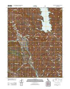
~ Benmore Canyon CA topo map, 1:24000 scale, 7.5 X 7.5 Minute, Historical, 2012
Benmore Canyon, California, USGS topographic map dated 2012.
Includes geographic coordinates (latitude and longitude). This topographic map is suitable for hiking, camping, and exploring, or framing it as a wall map.
Printed on-demand using high resolution imagery, on heavy weight and acid free paper, or alternatively on a variety of synthetic materials.
Topos available on paper, Waterproof, Poly, or Tyvek. Usually shipping rolled, unless combined with other folded maps in one order.
- Product Number: USGS-5602446
- Free digital map download (high-resolution, GeoPDF): Benmore Canyon, California (file size: 22 MB)
- Map Size: please refer to the dimensions of the GeoPDF map above
- Weight (paper map): ca. 55 grams
- Map Type: POD USGS Topographic Map
- Map Series: US Topo
- Map Verison: Historical
- Cell ID: 3335
- Datum: North American Datum of 1983
- Map Projection: Transverse Mercator
- Map Cell Name: Benmore Canyon
- Grid size: 7.5 X 7.5 Minute
- Date on map: 2012
- Map Scale: 1:24000
- Geographical region: California, United States
Neighboring Maps:
All neighboring USGS topo maps are available for sale online at a variety of scales.
Spatial coverage:
Topo map Benmore Canyon, California, covers the geographical area associated the following places:
- Chalk Mountain - Doe Canyon - Indian Valley 1080-002 Dam - Paradise Canyon - Wilson Glade Canyon - Long Valley Creek - Little Indian Valley (historical) - Indian Valley Reservoir - Kattenburg Canyon - Cold Spring Canyon - Cross Spring - Red Rocks - Zimory Canyon - Blue Oak Recreation Site - Paradise Canyon - Kilpepper Creek - Quartz Canyon - Panther Canyon - Wilson Glade - Sweet Hollow Creek - Cache Creek Rancheria (historical) - Hog Hollow Creek - Cold Canyon - Benmore Canyon - Bald Hill Canyon - Stony Top - Sulphur Spring (historical) - Northshore Fire Protection District Station 77 Spring Valley - Blodgett Canyon - Kowalski Spring Recreation Site - Box Canyon - Salt Lick Canyon - Spring Valley 396 Dam - Wolf Creek - Spring Valley Census Designated Place - Long Valley - Salt Canyon - Dow Ranch (historical)
- Map Area ID: AREA39.12539-122.625-122.5
- Northwest corner Lat/Long code: USGSNW39.125-122.625
- Northeast corner Lat/Long code: USGSNE39.125-122.5
- Southwest corner Lat/Long code: USGSSW39-122.625
- Southeast corner Lat/Long code: USGSSE39-122.5
- Northern map edge Latitude: 39.125
- Southern map edge Latitude: 39
- Western map edge Longitude: -122.625
- Eastern map edge Longitude: -122.5


