
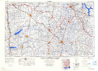
~ Tupelo MS topo map, 1:250000 scale, 1 X 2 Degree, Historical, 1984, updated 1984
Tupelo, Mississippi, USGS topographic map dated 1984.
Includes geographic coordinates (latitude and longitude). This topographic map is suitable for hiking, camping, and exploring, or framing it as a wall map.
Printed on-demand using high resolution imagery, on heavy weight and acid free paper, or alternatively on a variety of synthetic materials.
Topos available on paper, Waterproof, Poly, or Tyvek. Usually shipping rolled, unless combined with other folded maps in one order.
- Product Number: USGS-5599114
- Free digital map download (high-resolution, GeoPDF): Tupelo, Mississippi (file size: 13 MB)
- Map Size: please refer to the dimensions of the GeoPDF map above
- Weight (paper map): ca. 55 grams
- Map Type: POD USGS Topographic Map
- Map Series: HTMC
- Map Verison: Historical
- Cell ID: 69065
- Scan ID: 707642
- Imprint Year: 1984
- Visual Version Number: 3
- Datum: Unstated
- Map Projection: Transverse Mercator
- Map published by United States Army Corps of Engineers
- Map published by United States Army
- Map Language: English
- Scanner Resolution: 508 dpi
- Map Cell Name: Tupelo
- Grid size: 1 X 2 Degree
- Date on map: 1984
- Map Scale: 1:250000
- Geographical region: Mississippi, United States
Neighboring Maps:
All neighboring USGS topo maps are available for sale online at a variety of scales.
Spatial coverage:
Topo map Tupelo, Mississippi, covers the geographical area associated the following places:
- Crossroad - Lake City - Blythe Crossing - Pine Hill - North Park - Early Grove - Ripley - Chickasaw (historical) - Rienzi - Jonestown - Campbellton (historical) - Independence - Palestine - Coal Oil Corner - Enid - Buzzard Roost - Walnut - Confederate Park - Markette - College Hill - Brittany Woods - Camargo (historical) - Maud - Brownfield - Sandy Springs - Mack - Northwood Drive - Jumpertown - Verona - Walker (historical) - Poplar Springs - Bluff Springs - Ashland - Buena Vista - Oak Grove (historical) - Algoma - Hurricane - Shady Acres - Spring Hill - Eureka Springs - Lebanon - Waites - Teckville - Burnsville - Chesterville - Searcy Town - Short - Burgess - Harmontown - Slayden - Fairview - Wheeler - Porterton - Springville - Wright Subdivision - Ellard - Red Bay - Highland Circle - Rebecca Heights - Blair - Orion - Tishomingo - Wallerville - Coleville (historical) - Graham - Van Buren - Baldwyn - Water Valley - Bounds Crossroads - Mount Vernon - Hideaway Hills - Oakridge - Tiplersville - Good Springs (historical) - Hickory Flat - Shottsville - Sandy Creek Subdivision - Carter Branch - Hills Chapel - Mount Olivet - New Hope - Marietta - Central Academy - College Hill Heights - Northwood Estates - New Site - Hubbard Creek - Synagogue - Lespedeza - Blue Mountain - Fairview - Etta - Pannell - Auburn - Alpine - Crow - Cooks Landing - Dry Creek - Palmetto - Riverside
- Map Area ID: AREA3534-90-88
- Northwest corner Lat/Long code: USGSNW35-90
- Northeast corner Lat/Long code: USGSNE35-88
- Southwest corner Lat/Long code: USGSSW34-90
- Southeast corner Lat/Long code: USGSSE34-88
- Northern map edge Latitude: 35
- Southern map edge Latitude: 34
- Western map edge Longitude: -90
- Eastern map edge Longitude: -88


