
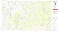
~ Woodville MS topo map, 1:100000 scale, 30 X 60 Minute, Historical, 1984, updated 1984
Woodville, Mississippi, USGS topographic map dated 1984.
Includes geographic coordinates (latitude and longitude). This topographic map is suitable for hiking, camping, and exploring, or framing it as a wall map.
Printed on-demand using high resolution imagery, on heavy weight and acid free paper, or alternatively on a variety of synthetic materials.
Topos available on paper, Waterproof, Poly, or Tyvek. Usually shipping rolled, unless combined with other folded maps in one order.
- Product Number: USGS-5599042
- Free digital map download (high-resolution, GeoPDF): Woodville, Mississippi (file size: 16 MB)
- Map Size: please refer to the dimensions of the GeoPDF map above
- Weight (paper map): ca. 55 grams
- Map Type: POD USGS Topographic Map
- Map Series: HTMC
- Map Verison: Historical
- Cell ID: 68615
- Scan ID: 337246
- Imprint Year: 1984
- Woodland Tint: Yes
- Aerial Photo Year: 1981
- Edit Year: 1984
- Datum: NAD27
- Map Projection: Universal Transverse Mercator
- Planimetric: Yes
- Map published by United States Geological Survey
- Map Language: English
- Scanner Resolution: 600 dpi
- Map Cell Name: Woodville
- Grid size: 30 X 60 Minute
- Date on map: 1984
- Map Scale: 1:100000
- Geographical region: Mississippi, United States
Neighboring Maps:
All neighboring USGS topo maps are available for sale online at a variety of scales.
Spatial coverage:
Topo map Woodville, Mississippi, covers the geographical area associated the following places:
- Esperance Landing - Point Breeze - Pinckneyville - Ellis Cliffs - Freewoods - Black Hawk - Darrington - Doloroso - Bougere - Cloverdale - Glade - Voorhies - Naples (historical) - Deer Park - Stephenson - Kienstra - Acme - White Apple - Donegal - Book - Tatum - Artonish - Centreville - Knoxville - Saukum - Lessley - Glasscock (historical) - Franklin - Armagh - Perrytown - New Era - Monterey - Parhams - Newtonia - Wilkinson - Merrick - Turnbull - Serena - Rosetta - Sibley - Big Bend - Larto - Moreauville - Garden City - Kingston - Red Fish - Eva - Hiram - Bordelonville - Fairview - Hamburg - Slocum - Coochie (historical) - Union Point - Jeannette - Ireland - Mount Pleasant - Ashland - Brabston (historical) - Hutchins Landing - Arnot - Ashridge (historical) - Whitaker - Delhoste - Woodville - Flat Rock - Crosby - Warnicott (historical) - Loch Leven - Crosby - Laneheart - Possum Corner - Mayna - Borodino - Shaw - Flowery Mound (historical) - Coles - Alton (historical) - Gloster - Fort Adams - Ashwood - Argo
- Map Area ID: AREA31.531-92-91
- Northwest corner Lat/Long code: USGSNW31.5-92
- Northeast corner Lat/Long code: USGSNE31.5-91
- Southwest corner Lat/Long code: USGSSW31-92
- Southeast corner Lat/Long code: USGSSE31-91
- Northern map edge Latitude: 31.5
- Southern map edge Latitude: 31
- Western map edge Longitude: -92
- Eastern map edge Longitude: -91


