
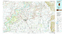
~ Clarksdale MS topo map, 1:100000 scale, 30 X 60 Minute, Historical, 1990, updated 1991
Clarksdale, Mississippi, USGS topographic map dated 1990.
Includes geographic coordinates (latitude and longitude). This topographic map is suitable for hiking, camping, and exploring, or framing it as a wall map.
Printed on-demand using high resolution imagery, on heavy weight and acid free paper, or alternatively on a variety of synthetic materials.
Topos available on paper, Waterproof, Poly, or Tyvek. Usually shipping rolled, unless combined with other folded maps in one order.
- Product Number: USGS-5598974
- Free digital map download (high-resolution, GeoPDF): Clarksdale, Mississippi (file size: 26 MB)
- Map Size: please refer to the dimensions of the GeoPDF map above
- Weight (paper map): ca. 55 grams
- Map Type: POD USGS Topographic Map
- Map Series: HTMC
- Map Verison: Historical
- Cell ID: 74922
- Scan ID: 337201
- Imprint Year: 1991
- Woodland Tint: Yes
- Aerial Photo Year: 1988
- Edit Year: 1990
- Datum: NAD27
- Map Projection: Universal Transverse Mercator
- Map published by United States Geological Survey
- Map Language: English
- Scanner Resolution: 600 dpi
- Map Cell Name: Clarksdale
- Grid size: 30 X 60 Minute
- Date on map: 1990
- Map Scale: 1:100000
- Geographical region: Mississippi, United States
Neighboring Maps:
All neighboring USGS topo maps are available for sale online at a variety of scales.
Spatial coverage:
Topo map Clarksdale, Mississippi, covers the geographical area associated the following places:
- Countiss - Pleasant Grove - Trenton - Wabash - Modoc - Fewell - West Marks - Stover - Westover - Essex - White Oak - Shutersville (historical) - Chancy - Sabino - Clover Hill - Mason Landing - Humber - Hiram - Watkins Corner - Fair Landing - Lakeview - Asa - Sunday (historical) - Modoc Landing - Sledge - Vance - Hushpuckena - Ingram (historical) - Popsons (historical) - Knowlton - Brazil - Glen Aubin - Danforth - Anderson Landing - Roseacres - Yellow Lake - Longstreet - Lorays - Wildwood (historical) - Curtis Station - Ewal - Farrell - Crumrod - Gobell - Sherard - Horatio - Green Grove - Bobo - Mims - Ragan - Riverview - New Hope (historical) - Delta - Francis - Mellwood - Robertsville (historical) - Sunflower Landing - Rich - Roundaway - Lula - Tocowa - Yarbrough - Long Lake - Birdie - Cypert - Crevi (historical) - Africa (historical) - Myrtle Hall - Pilgrims Rest - Stovall - Eleanor (historical) - Tutwiler - Fitch (historical) - Walnut - Counts - Lambrook - Old Town - Mosby Spur - Catron - Teasdale - Moon Lake (historical) - Walnut Grove - Gerald (historical) - Pullen - Alligator - Belen - Eagles Nest - Crowder - Duncan - Claremont - Deerfield - Lundell - Oneida - Hillhouse Landing - Ferguson Landing - Stokely - Beverly - Eldridge - Stokes (historical) - Barbee
- Map Area ID: AREA34.534-91-90
- Northwest corner Lat/Long code: USGSNW34.5-91
- Northeast corner Lat/Long code: USGSNE34.5-90
- Southwest corner Lat/Long code: USGSSW34-91
- Southeast corner Lat/Long code: USGSSE34-90
- Northern map edge Latitude: 34.5
- Southern map edge Latitude: 34
- Western map edge Longitude: -91
- Eastern map edge Longitude: -90


