
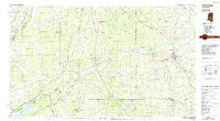
~ Carthage MS topo map, 1:100000 scale, 30 X 60 Minute, Historical, 1984, updated 1984
Carthage, Mississippi, USGS topographic map dated 1984.
Includes geographic coordinates (latitude and longitude). This topographic map is suitable for hiking, camping, and exploring, or framing it as a wall map.
Printed on-demand using high resolution imagery, on heavy weight and acid free paper, or alternatively on a variety of synthetic materials.
Topos available on paper, Waterproof, Poly, or Tyvek. Usually shipping rolled, unless combined with other folded maps in one order.
- Product Number: USGS-5598970
- Free digital map download (high-resolution, GeoPDF): Carthage, Mississippi (file size: 20 MB)
- Map Size: please refer to the dimensions of the GeoPDF map above
- Weight (paper map): ca. 55 grams
- Map Type: POD USGS Topographic Map
- Map Series: HTMC
- Map Verison: Historical
- Cell ID: 67248
- Scan ID: 337199
- Imprint Year: 1984
- Woodland Tint: Yes
- Aerial Photo Year: 1980
- Edit Year: 1984
- Datum: NAD27
- Map Projection: Universal Transverse Mercator
- Planimetric: Yes
- Map published by United States Geological Survey
- Map Language: English
- Scanner Resolution: 600 dpi
- Map Cell Name: Carthage
- Grid size: 30 X 60 Minute
- Date on map: 1984
- Map Scale: 1:100000
- Geographical region: Mississippi, United States
Neighboring Maps:
All neighboring USGS topo maps are available for sale online at a variety of scales.
Spatial coverage:
Topo map Carthage, Mississippi, covers the geographical area associated the following places:
- Carthage - Free Trade - Nile - Forest Grove - New Ireland - Arlington - Camden - Stallo - Tuscola - Lillian - Knox - Longino - Barfoot - Kitchener - Abdan - Dowdville - Linwood - Neville - Hays - Gray - Patterson - Rock Branch - Singleton - Loring - Raytown - Philadelphia - Greenland - Dossville - Bethsaida - Hopoca - Oaks - Renfroe - Tucker - Hope - Crossroad - Truitt - Vowell - Farmhaven - Freeny - Shoccoe - Dixon - Luther - Piggtown - Salem - Madisonville - Spring Hill - Midway - Good Hope - Alice - Madden - Richland - Williston - Williamsville - Bertice - Marydell - Contrell - Prospect - Standing Pine - Cameron - Greenfield (historical) - Ebenezer - New Hope (historical) - Beatline - Oka Hullo (historical) - Ratliff - Walnut Grove - Forty (historical) - Thomastown - Barnes - Sebastopol - Trapp - Pearl Hill - Cash - Ludlow - Drysdale - Eureka - Harmony - Bolatusha - Estesmill - Battle Bluff - Lucern - Goshen - Pilgrim Rest - Zaphyr Hill - Remus - Zemuly - Burnside - Smyrna - Lena - Oka Kapassa (historical) - Branchville (historical) - Laurel Hill - Stamper (historical) - Millville - Newport - Bloomfield - Turnetta - Edinburg - Ophelia (historical) - Hubbard
- Map Area ID: AREA3332.5-90-89
- Northwest corner Lat/Long code: USGSNW33-90
- Northeast corner Lat/Long code: USGSNE33-89
- Southwest corner Lat/Long code: USGSSW32.5-90
- Southeast corner Lat/Long code: USGSSE32.5-89
- Northern map edge Latitude: 33
- Southern map edge Latitude: 32.5
- Western map edge Longitude: -90
- Eastern map edge Longitude: -89


