
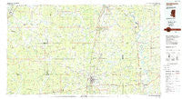
~ Brookhaven MS topo map, 1:100000 scale, 30 X 60 Minute, Historical, 1984, updated 1984
Brookhaven, Mississippi, USGS topographic map dated 1984.
Includes geographic coordinates (latitude and longitude). This topographic map is suitable for hiking, camping, and exploring, or framing it as a wall map.
Printed on-demand using high resolution imagery, on heavy weight and acid free paper, or alternatively on a variety of synthetic materials.
Topos available on paper, Waterproof, Poly, or Tyvek. Usually shipping rolled, unless combined with other folded maps in one order.
- Product Number: USGS-5598966
- Free digital map download (high-resolution, GeoPDF): Brookhaven, Mississippi (file size: 20 MB)
- Map Size: please refer to the dimensions of the GeoPDF map above
- Weight (paper map): ca. 55 grams
- Map Type: POD USGS Topographic Map
- Map Series: HTMC
- Map Verison: Historical
- Cell ID: 67188
- Scan ID: 337196
- Imprint Year: 1984
- Woodland Tint: Yes
- Aerial Photo Year: 1982
- Edit Year: 1984
- Datum: NAD27
- Map Projection: Universal Transverse Mercator
- Planimetric: Yes
- Map published by United States Geological Survey
- Map Language: English
- Scanner Resolution: 600 dpi
- Map Cell Name: Brookhaven
- Grid size: 30 X 60 Minute
- Date on map: 1984
- Map Scale: 1:100000
- Geographical region: Mississippi, United States
Neighboring Maps:
All neighboring USGS topo maps are available for sale online at a variety of scales.
Spatial coverage:
Topo map Brookhaven, Mississippi, covers the geographical area associated the following places:
- Hervey (historical) - Brookhaven - Crystal Springs - Fair River - Bowerton - Rockport - Violet - Barlow - Dentville - Hazlehurst - Old Georgetown (historical) - Eddiceton - Burnell - Ferguson - Hopewell - Bonus - Harmony - Oma - Union - Loyd Star - Holly Rood - Nola - Green Meadow - Cobbs - Gallatin - Zetus - Veto - Conn - Beech Grove - Schley - Browns Wells - Martinsville - Willing - Gordon - Cowanville - Pattona (historical) - Blue Hill - McBride - Linden (historical) - Carlos - Wesson - Pattison - Harrisville - Leedo (historical) - Quentin - Saint Elmo - Allen - Bridgeport - Gatesville - Kirby - Wanilla - Sontag - Stronghope - Sardis - Hermanville - McCall Creek - Elmo - Dennis Crossroads - New Sight - Williams - Barland - Montgomery - Woolworth - Ruby - Tillman - New Hope - Caseyville - Malcolm (historical) - Glancy - Fair Oak Springs - Sand Hill - Tryus - Cam - Beauregard - Jefferson - Coars Springs (historical) - Shucktown - Peyton - Shelby (historical) - Tillman - Red Lick - Lucien - Georgetown - Touchstone - Union Church - Monticello - Sarepta (historical) - Midway - Pearlhaven - Kinnaird (historical) - Arm - Hartman - Rafn - Kennolia - Ashley - Gallman - Hooker - Pleasant Hill - Shady Grove - Coaler (historical)
- Map Area ID: AREA3231.5-91-90
- Northwest corner Lat/Long code: USGSNW32-91
- Northeast corner Lat/Long code: USGSNE32-90
- Southwest corner Lat/Long code: USGSSW31.5-91
- Southeast corner Lat/Long code: USGSSE31.5-90
- Northern map edge Latitude: 32
- Southern map edge Latitude: 31.5
- Western map edge Longitude: -91
- Eastern map edge Longitude: -90


