
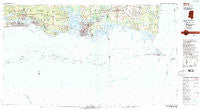
~ Biloxi MS topo map, 1:100000 scale, 30 X 60 Minute, Historical, 1982, updated 1982
Biloxi, Mississippi, USGS topographic map dated 1982.
Includes geographic coordinates (latitude and longitude). This topographic map is suitable for hiking, camping, and exploring, or framing it as a wall map.
Printed on-demand using high resolution imagery, on heavy weight and acid free paper, or alternatively on a variety of synthetic materials.
Topos available on paper, Waterproof, Poly, or Tyvek. Usually shipping rolled, unless combined with other folded maps in one order.
- Product Number: USGS-5598962
- Free digital map download (high-resolution, GeoPDF): Biloxi, Mississippi (file size: 15 MB)
- Map Size: please refer to the dimensions of the GeoPDF map above
- Weight (paper map): ca. 55 grams
- Map Type: POD USGS Topographic Map
- Map Series: HTMC
- Map Verison: Historical
- Cell ID: 67139
- Scan ID: 337194
- Imprint Year: 1982
- Woodland Tint: Yes
- Visual Version Number: 1
- Aerial Photo Year: 1980
- Edit Year: 1982
- Datum: NAD27
- Map Projection: Universal Transverse Mercator
- Map published by United States Geological Survey
- Map Language: English
- Scanner Resolution: 600 dpi
- Map Cell Name: Biloxi
- Grid size: 30 X 60 Minute
- Date on map: 1982
- Map Scale: 1:100000
- Geographical region: Mississippi, United States
Neighboring Maps:
All neighboring USGS topo maps are available for sale online at a variety of scales.
Spatial coverage:
Topo map Biloxi, Mississippi, covers the geographical area associated the following places:
- Ferguson's Mobile Home Park - Fort Bayou Estates - Blairs Trailer Park - Smithport - Lewis Mobile Park - Fairchilds Mobile Home Park - Oaklawn Mobile Home Park - CNA Estates Mobile Home Park - Pelican Mobile Home Park - Summit Mobile Home Park - South Orchard - Ford - Pecan - Pecan Grove Trailer Park - Ridgeland Mobile Home Park - Martins Pine Hill Estates - Starlite Mobile Home Park - East Side - Beachwood Mobile Home Park - North Biloxi - Rolling Hills Mobile Estates - Baker Mobile Home Park - Woodridge Estates Mobile Home Park - Pinecrest - Alabama Port - Bud's Mobile Park - Burroughs Mobile Park - Fernland - Bay Shore Mobile Court - Fowl River - Edgewater Park - Sunny Cove - Parkers Mobile Home Park - Bluff Creek Mobile Home Park - Spanish Oak Mobile Home Park - East Lawn Mobile Estates - Missala - Kirewakra - Rolling Heights Mobile Estates - Biloxi - Browns Mobile Park - Coden - South Pascagoula - Simmons Mobile Home Park - Gautier - Cedar Lake - Pine Grove Mobile Home Park - Pine Haven Mobile Home Village - Imperial Mobile Estates - Coast Meadows Mobile Home Park - Mon Louis - Hickory Hills - Krebs Mobile Park - Hidden River Mobile Ranch - Pascagoula - Sherwood Village Mobile Home Park - Fort Morgan - Cedar Lake Mobile Home Village - Bayou La Batre - Saint Martin - Heron Bay - Bayleys Corner - Ocean Springs - Woodland Park Mobile Home Village - Fort Gaines - East Pascagoula - Fountainebleau - Helena - Wool Market Mobile Home Park - Gulf Breeze Mobile Home Park - Moss Point - Fort Bayou (historical) - San Souci Beach - Escatawpa - Trade Winds Trailer Park - Sawmill Pointe - East Moss Point - Country Living Mobile Home Village - Heartease (historical) - Hilda - Omas Pine Mobile Home Park - B and H Mobile Home Park - Isle of Pines Mobile Home Village - Wool Market - Century Oaks Retirement Community Mobile Home Park - Oberts Mobile Park - Gulf Hills - Anchor Trailer Park - Dauphin Island - De Buys - Beauvoir - Isle of Pines Mobile Home Park - Twin Pines Mobile Home Park - Nelson - Grand Bay - Orange Grove - Delchamps - Mockingbird Hill Mobile Home Park - D'Iberville - Apple Valley Mobile Park
- Map Area ID: AREA30.530-89-88
- Northwest corner Lat/Long code: USGSNW30.5-89
- Northeast corner Lat/Long code: USGSNE30.5-88
- Southwest corner Lat/Long code: USGSSW30-89
- Southeast corner Lat/Long code: USGSSE30-88
- Northern map edge Latitude: 30.5
- Southern map edge Latitude: 30
- Western map edge Longitude: -89
- Eastern map edge Longitude: -88


