
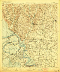
~ Bayou Sara LA topo map, 1:125000 scale, 30 X 30 Minute, Historical, 1906, updated 1921
Bayou Sara, Louisiana, USGS topographic map dated 1906.
Includes geographic coordinates (latitude and longitude). This topographic map is suitable for hiking, camping, and exploring, or framing it as a wall map.
Printed on-demand using high resolution imagery, on heavy weight and acid free paper, or alternatively on a variety of synthetic materials.
Topos available on paper, Waterproof, Poly, or Tyvek. Usually shipping rolled, unless combined with other folded maps in one order.
- Product Number: USGS-5595152
- Free digital map download (high-resolution, GeoPDF): Bayou Sara, Louisiana (file size: 9 MB)
- Map Size: please refer to the dimensions of the GeoPDF map above
- Weight (paper map): ca. 55 grams
- Map Type: POD USGS Topographic Map
- Map Series: HTMC
- Map Verison: Historical
- Cell ID: 64963
- Scan ID: 335203
- Imprint Year: 1921
- Survey Year: 1904
- Datum: Unstated
- Map Projection: Unstated
- Map published by United States Geological Survey
- Map Language: English
- Scanner Resolution: 600 dpi
- Map Cell Name: Bayou Sara
- Grid size: 30 X 30 Minute
- Date on map: 1906
- Map Scale: 1:125000
- Geographical region: Louisiana, United States
Neighboring Maps:
All neighboring USGS topo maps are available for sale online at a variety of scales.
Spatial coverage:
Topo map Bayou Sara, Louisiana, covers the geographical area associated the following places:
- Anchor - McHugh - Sweet Briar Mobile Home Park - Huntley Place - Bridlewood - Bethany Cooperative Community - Plantation Way - Patin - Airline Terrace - Holiday Acres - Alfords - New Roads - McGehee (historical) - Mannheim (historical) - Allen Landing - Cunnard Place - Sharon Hills - Oscar - Loudon - Woodaire - Timberlane - Hamilton - Welcome Heights - White Hills - Southern Heights - Chenal - Smithfield - Weyanoke - Port Hickey Landing - Rose Hill (historical) - Wayside (historical) - Fulda (historical) - Gibbens Place - Catalpa (historical) - Morgan Place - Morgan Place West - Mengel Landing - Torbert - Parkridge - Tolbert Place - Alma - Beechwood - Hermitage - Lazy Lake Estates - Huntington Park - Merrydale - Jackson - Moreco - Pinewood Acres - El Ranchito - Alsen Heights - Greenwood Estates - Jackson Road (historical) - Greenwell Acres East - Whispering Oaks - Erwinville - Mount Pleasant - Oakland - Brownsfield - Brandon Place - Glen Oaks - Cimmaron - Bakerfield - Pecan Ridge - Bon Dickey - Gurley - Forest Glen Estates - Monterey - Ambrosia (historical) - Carey - Plettenberg - Cypress Heights - Elm Park - Petite Place - Park Vista - Comite Hills - Milldale - Ridgewood - Mulatto Bend Landing - Island - Lincoln Heights - Klienpeter Terrace - Allon - Myrick Place - Yorkdale - Wickliffe - Bolwood Acres - Port Jackson (historical) - North Maryland - Yattan - Pointe Coupee - Saint Pius Place - Crystal Place Mobile Home Park - Grays - Rougon - Glenbrook - Little Lake Estates Mobile Home Park - Brentwood Place - Bueche - Forest Heights Park
- Map Area ID: AREA3130.5-91.5-91
- Northwest corner Lat/Long code: USGSNW31-91.5
- Northeast corner Lat/Long code: USGSNE31-91
- Southwest corner Lat/Long code: USGSSW30.5-91.5
- Southeast corner Lat/Long code: USGSSE30.5-91
- Northern map edge Latitude: 31
- Southern map edge Latitude: 30.5
- Western map edge Longitude: -91.5
- Eastern map edge Longitude: -91


