
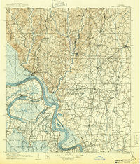
~ Bayou Sara LA topo map, 1:125000 scale, 30 X 30 Minute, Historical, 1906, updated 1943
Bayou Sara, Louisiana, USGS topographic map dated 1906.
Includes geographic coordinates (latitude and longitude). This topographic map is suitable for hiking, camping, and exploring, or framing it as a wall map.
Printed on-demand using high resolution imagery, on heavy weight and acid free paper, or alternatively on a variety of synthetic materials.
Topos available on paper, Waterproof, Poly, or Tyvek. Usually shipping rolled, unless combined with other folded maps in one order.
- Product Number: USGS-5595148
- Free digital map download (high-resolution, GeoPDF): Bayou Sara, Louisiana (file size: 10 MB)
- Map Size: please refer to the dimensions of the GeoPDF map above
- Weight (paper map): ca. 55 grams
- Map Type: POD USGS Topographic Map
- Map Series: HTMC
- Map Verison: Historical
- Cell ID: 64963
- Scan ID: 335201
- Imprint Year: 1943
- Survey Year: 1904
- Datum: Unstated
- Map Projection: Polyconic
- Map published by United States Geological Survey
- Map Language: English
- Scanner Resolution: 600 dpi
- Map Cell Name: Bayou Sara
- Grid size: 30 X 30 Minute
- Date on map: 1906
- Map Scale: 1:125000
- Geographical region: Louisiana, United States
Neighboring Maps:
All neighboring USGS topo maps are available for sale online at a variety of scales.
Spatial coverage:
Topo map Bayou Sara, Louisiana, covers the geographical area associated the following places:
- McHugh - Shexnayder - Engleswood - Woods Edge - Merrydale - Belmont Landing - Holiday Acres - Jackson Road (historical) - Retreat - Arbroth - Town and Country Mobile Home Village - Comite Hills - Jarreau - Monterey - Plettenberg - Chenal - Joor Road Mobile Home Park - Carey - Sherrington Place - Solitude - Glenbrook - Browns - Golden Ridge - Pointe Coupee - Chamberlin - Weyanoke - Tolbert Place - Deerford - Ploup - Beechwood - Laurel Hill - Glen Oaks Place - Wyatt Subdivision - Hamilton - Brooks - Boganvilla - Allen Landing - Oakland - Bon Dickey - Beachwood - Scotland - Parkridge - Fred - Grays - Dugan Landing - Maryland - Green Acres - Irene - Ingleside - Torbert - Paloma (historical) - Wilson - Pinewood Acres - Lakeland - Comite Estates - Bonn - Cunnard Place - Oak Glen Terrace Mobile Home Park - Anchor - Rogillioville - Port Hudson - Plantation Way - Turnbull - Ventress - Glynn - Willow Creek - Brandon Place - Baker Estates - Majors - Norwood - Phebus - Devalls - Tanglewood - Alsen Heights - Parlange - Central Estates - Willowood Acres - Sharon Hills - Ellen Place - Central - Jackson - Feliciana - Waterloo - White Oak Run - Welcome Heights - Brownsfield - Bueche - East Fairlane - Myrick Place - Rambling Oaks - Morgan Place - Cimmaron - Cole - Island - Clinton - Yattan - Zion City - Rosebank - Cedar Mill Run - Ski Stone
- Map Area ID: AREA3130.5-91.5-91
- Northwest corner Lat/Long code: USGSNW31-91.5
- Northeast corner Lat/Long code: USGSNE31-91
- Southwest corner Lat/Long code: USGSSW30.5-91.5
- Southeast corner Lat/Long code: USGSSE30.5-91
- Northern map edge Latitude: 31
- Southern map edge Latitude: 30.5
- Western map edge Longitude: -91.5
- Eastern map edge Longitude: -91


