
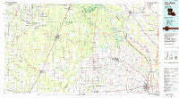
~ Ville Platte LA topo map, 1:100000 scale, 30 X 60 Minute, Historical, 1986, updated 1986
Ville Platte, Louisiana, USGS topographic map dated 1986.
Includes geographic coordinates (latitude and longitude). This topographic map is suitable for hiking, camping, and exploring, or framing it as a wall map.
Printed on-demand using high resolution imagery, on heavy weight and acid free paper, or alternatively on a variety of synthetic materials.
Topos available on paper, Waterproof, Poly, or Tyvek. Usually shipping rolled, unless combined with other folded maps in one order.
- Product Number: USGS-5595136
- Free digital map download (high-resolution, GeoPDF): Ville Platte, Louisiana (file size: 19 MB)
- Map Size: please refer to the dimensions of the GeoPDF map above
- Weight (paper map): ca. 55 grams
- Map Type: POD USGS Topographic Map
- Map Series: HTMC
- Map Verison: Historical
- Cell ID: 68528
- Scan ID: 335195
- Imprint Year: 1986
- Woodland Tint: Yes
- Aerial Photo Year: 1983
- Edit Year: 1986
- Datum: NAD27
- Map Projection: Universal Transverse Mercator
- Planimetric: Yes
- Map published by United States Geological Survey
- Map Language: English
- Scanner Resolution: 600 dpi
- Map Cell Name: Ville Platte
- Grid size: 30 X 60 Minute
- Date on map: 1986
- Map Scale: 1:100000
- Geographical region: Louisiana, United States
Neighboring Maps:
All neighboring USGS topo maps are available for sale online at a variety of scales.
Spatial coverage:
Topo map Ville Platte, Louisiana, covers the geographical area associated the following places:
- McNary - Savoy - Barbreck - Emad - Marionville (historical) - Reids - F and F Mobile Home Park - Clearwater - Bernard - Gray Point - Redland - Bond - Chappel (historical) - Morrow - Eola - Lake Cove - Beaver - Belle Chaney (historical) - Ville Platte - Dora (historical) - Hickory - Johnson Landing - Prairie Ronde - Chataignier - Opelousas - Bayou Chicot - Barber Spur - Saint Landry - Bubenzer - Oakdale - Saint Louis - Moeling (historical) - Hampton - Oberlin - Haas - Whiteville - Blanche - Clubhouse Landing - Tate Cove - Ward - Veazie - Carboco - Westport - Meridian - Rosa - Lyles - Stewart (historical) - Mab - Ledoux - Gum Ridge (historical) - Swords - Blue Lake Landing - Notelyville - Union Hill - Gold Dust - Soileau - Osburn - Fullerton - Turkey Creek - Boretta - Kelley (historical) - Canton - Elder - Dossman - McDonald (historical) - Washington - Fenris - Mamou - Shirley (historical) - Augusta - Degeneres - Le Blanc - Elizabeth - Soileau - Faubourg - Clarks Landing - Enterprise - Bennett Bay Landing - Dido - Le Jeune - Bethel - Tenmile - Deats (historical) - Easton - Harmony - Pine Prairie - Hester Landing - Omo (historical) - Reddell - Nobrac - Nuba - Fords (historical) - Centerville - Grant - Belair Cove - Big Cane - Beale - Pitkin - Goudeau - Frilot Cove
- Map Area ID: AREA3130.5-93-92
- Northwest corner Lat/Long code: USGSNW31-93
- Northeast corner Lat/Long code: USGSNE31-92
- Southwest corner Lat/Long code: USGSSW30.5-93
- Southeast corner Lat/Long code: USGSSE30.5-92
- Northern map edge Latitude: 31
- Southern map edge Latitude: 30.5
- Western map edge Longitude: -93
- Eastern map edge Longitude: -92


