
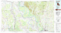
~ New Roads LA topo map, 1:100000 scale, 30 X 60 Minute, Historical, 1983, updated 1983
New Roads, Louisiana, USGS topographic map dated 1983.
Includes geographic coordinates (latitude and longitude). This topographic map is suitable for hiking, camping, and exploring, or framing it as a wall map.
Printed on-demand using high resolution imagery, on heavy weight and acid free paper, or alternatively on a variety of synthetic materials.
Topos available on paper, Waterproof, Poly, or Tyvek. Usually shipping rolled, unless combined with other folded maps in one order.
- Product Number: USGS-5595114
- Free digital map download (high-resolution, GeoPDF): New Roads, Louisiana (file size: 25 MB)
- Map Size: please refer to the dimensions of the GeoPDF map above
- Weight (paper map): ca. 55 grams
- Map Type: POD USGS Topographic Map
- Map Series: HTMC
- Map Verison: Historical
- Cell ID: 68044
- Scan ID: 335183
- Imprint Year: 1983
- Woodland Tint: Yes
- Visual Version Number: 1
- Aerial Photo Year: 1980
- Edit Year: 1983
- Datum: NAD27
- Map Projection: Universal Transverse Mercator
- Map published by United States Geological Survey
- Map Language: English
- Scanner Resolution: 600 dpi
- Map Cell Name: New Roads
- Grid size: 30 X 60 Minute
- Date on map: 1983
- Map Scale: 1:100000
- Geographical region: Louisiana, United States
Neighboring Maps:
All neighboring USGS topo maps are available for sale online at a variety of scales.
Spatial coverage:
Topo map New Roads, Louisiana, covers the geographical area associated the following places:
- Park Manor - Ridgewood - Lebeau - McClure Place - Aline - Majors - Forest Heights Park - Carney - Alford Acres - Tanglewood West Trailer Park - Frisbie (historical) - Whispering Oaks - Basel (historical) - Cunnard Place - Morrison - McManus - Knapp - Retreat - Jackson - White Oak Run - Red River Landing - Kingston Estates - Azalea Gardens Mobile Home and Recreational Vehicle Park - Gurley - Petite Place - Fordoche - Gordon - Melville - Golden Ridge - Wakefield - Oak Shadows Place - Immaculata - Powell Ridge - Airline Terrace - Solitude - Monterey - Bobby Lejeune Mobile Home Park - Plettenberg - Converse (historical) - Kerne (historical) - Bonn - Hamilton - Argyle Plantation - Morgan Place West - Frisco - Lottie - Yorkdale - Jackson Road (historical) - Delano (historical) - Irene - Gibbs - Oakland - Hollywood - Morgan Place - Myrick Place - Erwinville - Wayside (historical) - Gibbens Place - Quinton - Port Barre - Bells Store (historical) - New Roads - Willow Creek - Parkwood Terrace - Paloma (historical) - Plaucheville - Scotlandville - Baker Estates - Angola Landing - Harding Heights - Bueche - Brownview - Darbonne - Keller - Argyle - Greenwood - Tunica - Catalpa (historical) - Bayou Jack - Carmel Acres - Hallf Moon - Lakeland - Plains - Woodaire - Odenburg - Torras Landing - Brownville (historical) - Forest Glen Estates - Starhill - Labarre - Central Place - Waxia - Bolden - Jarreau - Forest Park - Saint James Mobile Home Community - Grays - Blanks - Cimmaron - Woodland View
- Map Area ID: AREA3130.5-92-91
- Northwest corner Lat/Long code: USGSNW31-92
- Northeast corner Lat/Long code: USGSNE31-91
- Southwest corner Lat/Long code: USGSSW30.5-92
- Southeast corner Lat/Long code: USGSSE30.5-91
- Northern map edge Latitude: 31
- Southern map edge Latitude: 30.5
- Western map edge Longitude: -92
- Eastern map edge Longitude: -91


