
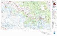
~ Morgan City LA topo map, 1:100000 scale, 30 X 60 Minute, Historical, 1983, updated 1983
Morgan City, Louisiana, USGS topographic map dated 1983.
Includes geographic coordinates (latitude and longitude). This topographic map is suitable for hiking, camping, and exploring, or framing it as a wall map.
Printed on-demand using high resolution imagery, on heavy weight and acid free paper, or alternatively on a variety of synthetic materials.
Topos available on paper, Waterproof, Poly, or Tyvek. Usually shipping rolled, unless combined with other folded maps in one order.
- Product Number: USGS-5595102
- Free digital map download (high-resolution, GeoPDF): Morgan City, Louisiana (file size: 29 MB)
- Map Size: please refer to the dimensions of the GeoPDF map above
- Weight (paper map): ca. 55 grams
- Map Type: POD USGS Topographic Map
- Map Series: HTMC
- Map Verison: Historical
- Cell ID: 67988
- Scan ID: 335177
- Imprint Year: 1983
- Woodland Tint: Yes
- Visual Version Number: 1
- Aerial Photo Year: 1975
- Edit Year: 1983
- Datum: NAD27
- Map Projection: Universal Transverse Mercator
- Map published by United States Geological Survey
- Map Language: English
- Scanner Resolution: 600 dpi
- Map Cell Name: Morgan City
- Grid size: 30 X 60 Minute
- Date on map: 1983
- Map Scale: 1:100000
- Geographical region: Louisiana, United States
Neighboring Maps:
All neighboring USGS topo maps are available for sale online at a variety of scales.
Spatial coverage:
Topo map Morgan City, Louisiana, covers the geographical area associated the following places:
- Tree Lawn Trailer Court - Bellewood - Cypremort - Avoca - Lifenite - Farmers - Camperdown - Johnson - Munsons - Ludger - Midway - Fredericks Mobile Home Park - Avalon - Napoleonville - Percle - Baldwin - Charlies Mobile Home Village - Kilgore Plantation - Lydia - Bodin - Lasalle - Bonvillain - Lagonda - Glencoe - Berwick - Violas Mobile Home Park - Ursa - Verdunville - Morgan City Beach - Caffery - Jefferson Island - Patoutville - Alice B - Iberia Mobile Home Park - Greig - Ramos - Todd - Dumesnil - Oakley - Luke Landing - Fairville - Richland - Pesson - Enola - Bayou Geneve - Glenwood - Loisel - Parro Mobile Home Park - Maria - Amelia - Centerville - Deslatte - Morgan City - Katy - Cote Blanche Landing - Freetown - Derouen - Fish Island - Burns - Cypremort Point - Bob Acres - Gall - Berard - Marce - Gordy - Matilda - Gajan - Landry - Little Texas - Poufette - Elm Hall Junction - Stephenville - Boudreaux's Mobile Home Park - Cefalu Mobile Home Park - Maryland - Fivemile Oaks - Siracusaville - Fairfax - Rodriquez - Lower Texas - Cabot - Weeks - Rynella - Oxford - Linwood - Glenwild - Caneland - Balco - Oaklawn - Port of Iberia - Englewood - Sandager - Emma - Masters - Gahn - Boudreaux - Bayou Vista - Attakapas Canal - Delcambre - Little Valley Plantation
- Map Area ID: AREA3029.5-92-91
- Northwest corner Lat/Long code: USGSNW30-92
- Northeast corner Lat/Long code: USGSNE30-91
- Southwest corner Lat/Long code: USGSSW29.5-92
- Southeast corner Lat/Long code: USGSSE29.5-91
- Northern map edge Latitude: 30
- Southern map edge Latitude: 29.5
- Western map edge Longitude: -92
- Eastern map edge Longitude: -91


