
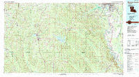
~ Monroe South LA topo map, 1:100000 scale, 30 X 60 Minute, Historical, 1985, updated 1988
Monroe South, Louisiana, USGS topographic map dated 1985.
Includes geographic coordinates (latitude and longitude). This topographic map is suitable for hiking, camping, and exploring, or framing it as a wall map.
Printed on-demand using high resolution imagery, on heavy weight and acid free paper, or alternatively on a variety of synthetic materials.
Topos available on paper, Waterproof, Poly, or Tyvek. Usually shipping rolled, unless combined with other folded maps in one order.
- Product Number: USGS-5595098
- Free digital map download (high-resolution, GeoPDF): Monroe South, Louisiana (file size: 28 MB)
- Map Size: please refer to the dimensions of the GeoPDF map above
- Weight (paper map): ca. 55 grams
- Map Type: POD USGS Topographic Map
- Map Series: HTMC
- Map Verison: Historical
- Cell ID: 67975
- Scan ID: 335175
- Imprint Year: 1988
- Woodland Tint: Yes
- Aerial Photo Year: 1983
- Edit Year: 1985
- Datum: NAD27
- Map Projection: Universal Transverse Mercator
- Map published by United States Geological Survey
- Map Language: English
- Scanner Resolution: 600 dpi
- Map Cell Name: Monroe South
- Grid size: 30 X 60 Minute
- Date on map: 1985
- Map Scale: 1:100000
- Geographical region: Louisiana, United States
Neighboring Maps:
All neighboring USGS topo maps are available for sale online at a variety of scales.
Spatial coverage:
Topo map Monroe South, Louisiana, covers the geographical area associated the following places:
- Tama - Milams - Hunt (historical) - Logtown - Hill - Longstraw - Myatt (historical) - Columbia Heights - Cobb - Newman (historical) - Cox Crossing - Bryceland - Carolina - Gansville - Wood Junction - Ebenzer - Okaloosa - Hickory Valley - Anabel - Brewtons Mill - Garden Park - Saline - Womack - Mount Pleasant - Chester - Mount Hebron - Old Mount Pleasant (historical) - Sikes - Evergreen - Wyatt - Mill - Pulpwood Spur - Bienville - Pleasant Hill - Indian Village - New Friendship - Old Newport (historical) - Richwood - Charmingdale - Grayson - East Parkview - Sunnybrook Farms - Mount Moriah - Brownsville - Pine Grove - East Hodge - Shady - Steven - Zoar - Lyons - Summit - Dalley (historical) - Antioch - Shull (historical) - Tanglewood - Punkin Center - Forest Oaks - Kelly Front (historical) - Loe - Vernon - Columbia - Riverton - Dodson - Gaars Mill - Siegle - Quitman - Saint Claire - Ridgecrest - Redwine (historical) - Brooklyn (historical) - Hebron - Kings Oaks - Cotton Plant - Blankston - Cadeville - Liberty Hill - Winona (historical) - Clarks - Cypress - Oak Grove - West Heights - Crowson - Copenhagen - Southwinds - Chatham - Banks Springs - Huntington Park - Robinson Place - Hickory Springs (historical) - Luna - Cartwright - Bethlehem - Gulf Crossing - English - Mount Zion (historical) - Mineral Springs - Lapine - Readheimer - Driscoll (historical) - Cooper (historical)
- Map Area ID: AREA32.532-93-92
- Northwest corner Lat/Long code: USGSNW32.5-93
- Northeast corner Lat/Long code: USGSNE32.5-92
- Southwest corner Lat/Long code: USGSSW32-93
- Southeast corner Lat/Long code: USGSSE32-92
- Northern map edge Latitude: 32.5
- Southern map edge Latitude: 32
- Western map edge Longitude: -93
- Eastern map edge Longitude: -92


