
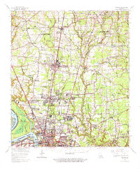
~ Zachary LA topo map, 1:62500 scale, 15 X 15 Minute, Historical, 1963, updated 1971
Zachary, Louisiana, USGS topographic map dated 1963.
Includes geographic coordinates (latitude and longitude). This topographic map is suitable for hiking, camping, and exploring, or framing it as a wall map.
Printed on-demand using high resolution imagery, on heavy weight and acid free paper, or alternatively on a variety of synthetic materials.
Topos available on paper, Waterproof, Poly, or Tyvek. Usually shipping rolled, unless combined with other folded maps in one order.
- Product Number: USGS-5595038
- Free digital map download (high-resolution, GeoPDF): Zachary, Louisiana (file size: 9 MB)
- Map Size: please refer to the dimensions of the GeoPDF map above
- Weight (paper map): ca. 55 grams
- Map Type: POD USGS Topographic Map
- Map Series: HTMC
- Map Verison: Historical
- Cell ID: 64818
- Scan ID: 335140
- Imprint Year: 1971
- Woodland Tint: Yes
- Datum: NAD27
- Map Projection: Polyconic
- Map published by United States Geological Survey
- Map Language: English
- Scanner Resolution: 600 dpi
- Map Cell Name: Zachary
- Grid size: 15 X 15 Minute
- Date on map: 1963
- Map Scale: 1:62500
- Geographical region: Louisiana, United States
Neighboring Maps:
All neighboring USGS topo maps are available for sale online at a variety of scales.
Spatial coverage:
Topo map Zachary, Louisiana, covers the geographical area associated the following places:
- Merrydale - Belmont Landing - Holiday Acres - Mengel Landing - Oak Glen Terrace Mobile Home Park - Tolbert Place - Highland Farms - Scotland - Jackson Place - North Maryland - McClure Place - Carmel Acres - Baker Estates - Central Place - Brian Estates - Moreco - Scotlandville - Huntley Place - Central - Hidden Creek - Crestworth - Comite Hills West - Cunnard Place - Glen Oaks Place - Ambrosia (historical) - Airline Terrace - Tanglewood - Glenbrook - Parkwood Terrace - Lincoln Heights - Lazy Lake Estates - Ellen Place - Ski Stone - Southern Heights - Rolling Acres - Mickens Place - Morgan Place - Kingston Estates - Plains - Forest Heights Park - Brownsfield - Oak Shadows Place - Pleasant Hills - East Fairlane - Azalea Gardens Mobile Home and Recreational Vehicle Park - White Hills - Bon Dickey - Tristian Village - Green Gate - Wyatt Subdivision - Baker Hills - Twin Oaks - Northeast Place - Rambling Oaks - Bakerfield - Woods Edge - Harding Heights - Bolwood Acres - Timberlane - Greenwell Acres East - McHugh - Park Manor - Engleswood - Liberty Farms - Four Season Mobile Home Park - Howell - Crestview Village Mobile Home Park - Beechwood - Baker - Jackson Road (historical) - Pecan Ridge - Cedar Glen - Mulatto Bend Landing - Dude's Trailer Park - Gibbens Place - Woodland View - Golden Ridge - Willow Creek - Winchester - Greendale - Cedar Mill Run - Milldale - Boganvilla - Forest Park - Brandon Place - Zachary - Sherrington Place - Glen Oaks - White Oak Run - Lindsay - Kings Estates - Brentwood Place - Phebus - Brownsfield - Waters Edge - Saint Pius Place - East Glen - Monte Sano Trailer Park - Petite Place - Fred
- Map Area ID: AREA30.7530.5-91.25-91
- Northwest corner Lat/Long code: USGSNW30.75-91.25
- Northeast corner Lat/Long code: USGSNE30.75-91
- Southwest corner Lat/Long code: USGSSW30.5-91.25
- Southeast corner Lat/Long code: USGSSE30.5-91
- Northern map edge Latitude: 30.75
- Southern map edge Latitude: 30.5
- Western map edge Longitude: -91.25
- Eastern map edge Longitude: -91


