
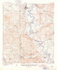
~ Pollock LA topo map, 1:62500 scale, 15 X 15 Minute, Historical, 1936, updated 1949
Pollock, Louisiana, USGS topographic map dated 1936.
Includes geographic coordinates (latitude and longitude). This topographic map is suitable for hiking, camping, and exploring, or framing it as a wall map.
Printed on-demand using high resolution imagery, on heavy weight and acid free paper, or alternatively on a variety of synthetic materials.
Topos available on paper, Waterproof, Poly, or Tyvek. Usually shipping rolled, unless combined with other folded maps in one order.
- Product Number: USGS-5594692
- Free digital map download (high-resolution, GeoPDF): Pollock, Louisiana (file size: 8 MB)
- Map Size: please refer to the dimensions of the GeoPDF map above
- Weight (paper map): ca. 55 grams
- Map Type: POD USGS Topographic Map
- Map Series: HTMC
- Map Verison: Historical
- Cell ID: 61137
- Scan ID: 334937
- Imprint Year: 1949
- Survey Year: 1934
- Datum: NAD27
- Map Projection: Polyconic
- Map published by United States Geological Survey
- Map Language: English
- Scanner Resolution: 600 dpi
- Map Cell Name: Pollock
- Grid size: 15 X 15 Minute
- Date on map: 1936
- Map Scale: 1:62500
- Geographical region: Louisiana, United States
Neighboring Maps:
All neighboring USGS topo maps are available for sale online at a variety of scales.
Spatial coverage:
Topo map Pollock, Louisiana, covers the geographical area associated the following places:
- White Sulphur Springs - Hester - Manistee (historical) - Breezy Hill - Sand Spur - Farmland - Little Creek - Ganeyville - Zenoria - Antonia - Bentley - Fishville - Lincecum - Pollock - Camp Hardtner - Mudville - Howcott - Selma
- Map Area ID: AREA31.7531.5-92.5-92.25
- Northwest corner Lat/Long code: USGSNW31.75-92.5
- Northeast corner Lat/Long code: USGSNE31.75-92.25
- Southwest corner Lat/Long code: USGSSW31.5-92.5
- Southeast corner Lat/Long code: USGSSE31.5-92.25
- Northern map edge Latitude: 31.75
- Southern map edge Latitude: 31.5
- Western map edge Longitude: -92.5
- Eastern map edge Longitude: -92.25


