
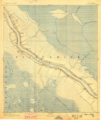
~ Pointe a La Hache LA topo map, 1:62500 scale, 15 X 15 Minute, Historical, 1892, updated 1898
Pointe a La Hache, Louisiana, USGS topographic map dated 1892.
Includes geographic coordinates (latitude and longitude). This topographic map is suitable for hiking, camping, and exploring, or framing it as a wall map.
Printed on-demand using high resolution imagery, on heavy weight and acid free paper, or alternatively on a variety of synthetic materials.
Topos available on paper, Waterproof, Poly, or Tyvek. Usually shipping rolled, unless combined with other folded maps in one order.
- Product Number: USGS-5594684
- Free digital map download (high-resolution, GeoPDF): Pointe a La Hache, Louisiana (file size: 9 MB)
- Map Size: please refer to the dimensions of the GeoPDF map above
- Weight (paper map): ca. 55 grams
- Map Type: POD USGS Topographic Map
- Map Series: HTMC
- Map Verison: Historical
- Cell ID: 61124
- Scan ID: 334932
- Imprint Year: 1898
- Survey Year: 1891
- Datum: Unstated
- Map Projection: Unstated
- Map published by United States Geological Survey
- Map Language: English
- Scanner Resolution: 600 dpi
- Map Cell Name: Pointe a la Hache
- Grid size: 15 X 15 Minute
- Date on map: 1892
- Map Scale: 1:62500
- Geographical region: Louisiana, United States
Neighboring Maps:
All neighboring USGS topo maps are available for sale online at a variety of scales.
Spatial coverage:
Topo map Pointe a La Hache, Louisiana, covers the geographical area associated the following places:
- Reussite - Alliance - Deer Range - Socola - Phoenix - Grand Bayou - Fosters Canal - Barthelemy Settlement - Martin - Myrtle Grove - Ironton - Bellevue - Davant - Burnbridge - Naomi - Grand Bayou Village (historical) - West Pointe A La Hache - La Reussite - Monsecour - Nero - Harlem - Point Celeste - Bohemia - Magnolia - Pointe à la Hache - Filipino (historical) - Burbridge - Carlisle - Beshel - Woodland - Diamond - Lake Judge Perez - Saint Rosalie - Belair
- Map Area ID: AREA29.7529.5-90-89.75
- Northwest corner Lat/Long code: USGSNW29.75-90
- Northeast corner Lat/Long code: USGSNE29.75-89.75
- Southwest corner Lat/Long code: USGSSW29.5-90
- Southeast corner Lat/Long code: USGSSE29.5-89.75
- Northern map edge Latitude: 29.75
- Southern map edge Latitude: 29.5
- Western map edge Longitude: -90
- Eastern map edge Longitude: -89.75


