
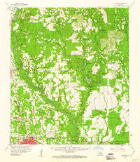
~ Hammond LA topo map, 1:62500 scale, 15 X 15 Minute, Historical, 1959, updated 1960
Hammond, Louisiana, USGS topographic map dated 1959.
Includes geographic coordinates (latitude and longitude). This topographic map is suitable for hiking, camping, and exploring, or framing it as a wall map.
Printed on-demand using high resolution imagery, on heavy weight and acid free paper, or alternatively on a variety of synthetic materials.
Topos available on paper, Waterproof, Poly, or Tyvek. Usually shipping rolled, unless combined with other folded maps in one order.
- Product Number: USGS-5594152
- Free digital map download (high-resolution, GeoPDF): Hammond, Louisiana (file size: 9 MB)
- Map Size: please refer to the dimensions of the GeoPDF map above
- Weight (paper map): ca. 55 grams
- Map Type: POD USGS Topographic Map
- Map Series: HTMC
- Map Verison: Historical
- Cell ID: 55027
- Scan ID: 334628
- Imprint Year: 1960
- Woodland Tint: Yes
- Aerial Photo Year: 1954
- Survey Year: 1959
- Datum: NAD27
- Map Projection: Polyconic
- Map published by United States Geological Survey
- Map Language: English
- Scanner Resolution: 600 dpi
- Map Cell Name: Hammond
- Grid size: 15 X 15 Minute
- Date on map: 1959
- Map Scale: 1:62500
- Geographical region: Louisiana, United States
Neighboring Maps:
All neighboring USGS topo maps are available for sale online at a variety of scales.
Spatial coverage:
Topo map Hammond, Louisiana, covers the geographical area associated the following places:
- Velma - Henry City (historical) - Uneedus - Epney (historical) - Osceola - Holton - Tickfaw - Westdale - Lincoln Park - Lorraine - Genessee - Oak Ridge - Hammond - Viola (historical) - Natalbany - Husser - Robert - Superior Mobile Home Park - Mason (historical) - University Place - Coburn - Whiskey Lane Mobile Home Park - South Bilt - Marburyville (historical) - Tallow Wood - Bellewood - Loranger - Hollyridge - Cranky Corner - Whitmar Acres - Woodland Park - Woodbridge
- Map Area ID: AREA30.7530.5-90.5-90.25
- Northwest corner Lat/Long code: USGSNW30.75-90.5
- Northeast corner Lat/Long code: USGSNE30.75-90.25
- Southwest corner Lat/Long code: USGSSW30.5-90.5
- Southeast corner Lat/Long code: USGSSE30.5-90.25
- Northern map edge Latitude: 30.75
- Southern map edge Latitude: 30.5
- Western map edge Longitude: -90.5
- Eastern map edge Longitude: -90.25


